
Demonym(s) Iglesienti Patron saint Clare of Assisi | Region Sardinia Elevation 200 m (700 ft) Area 207.6 km² Postal code 09016 | |
 | ||
Frazioni Barega, Bindua, Corongiu, Masua, Monte Agruxiau, Monteponi, Nebida, San Benedetto, San Giovanni Miniera, Tanì Weather 18°C, Wind N at 11 km/h, 73% Humidity | ||
Iglesias ([iˈɡlɛːzjas] or [iˈɡlezjas]; Sardinian: Igrèsias) is a comune and city of the province of South Sardinia, region of Sardinia, Italy. It was the co-capital of the ex province of Carbonia-Iglesias (along with Carbonia) as well as its second-largest community.
Contents
- Map of Iglesias Province of Carbonia Iglesias Italy
- Prehistory and ancient History
- Medieval history
- Modern and contemporary history
- Demographics
- Economy
- Castle of Salvaterra
- Santa Chiara Cathedral
- Church of San Francesco
- Church of Santa Maria di Valverde
- Medieval fortifications
- Town Hall
- Sanctuary of Madonna delle Grazie
- Mining Art Museum
- Historical Archive
- Flavia port
- Monteponi mine
- Saint Michele Church
- Saint Giuseppe Church
- Purissima Church
- Saint Domenico Church
- Saint Marcello Church
- Saint Antonio Abbot
- Saint Salvatore Church
- Saint Francesco Cloister
- Monumental Cemetery
- Piazza Sella
- Piazza Oberdan
- Saint Barbara Cave
- Cala Domestica Tower
- Mineralogical Museum
- Museum Of Minerary Art
- Coastal territory bays and beaches
- Twin towns Sister cities
- Tourist Informations
- References
Map of Iglesias, Province of Carbonia-Iglesias, Italy
In the period of Spanish control, the city was one of the most important royal cities of Sardinia. It is also episcopal seat (Roman Catholic Diocese of Iglesias). Situated at an elevation of 190 metres (620 ft) in the hills in the southwest of Sardinia, it was a centre of a mining district where lead, zinc, and silver were extracted. It was also a centre for the distillation of sulfuric acid.
Prehistory and ancient History
The area where today stands the city of Iglesias was already inhabited in prehistoric times: the oldest traces of human settlement date back to the Neolithic. To the Ozieri culture (fourth millennium BC) date the domus de Janas discovered in the mountainous area of San Benedetto. Also belong to the prenuragic period finds found in nearby caves attributable to the cultures of Monte Claro, Bell Beaker and Bonnanaro. Follow further traces of Nuragic, Punic and Roman presences. The ancient sources speak of a city called Metalla, perhaps located along the border with Fluminimaggiore.
Medieval history
From ninth century, after a period of human absence, there was a little urban centre proved by the presence of a Byzantine church (Church of San Salvatore). After, when Byzantine left the island, the territory, called Cixerri, was under Giudicato of Cagliari's control. In the 1258, after the fall of the Giudicato, its south-west portion (curatorie of Cixerri and Sulcis) was assigned to the pisan Della Gherardesca family. The Cixerri part was under the count Ugolino Della Gherardesca's control. The count decided to take advantage of the silver resources present in the zone, so he founded a new city, called in Latin "Villa Ecclesiae" (or Villa di Chiesa, Church's Villa), developing the old structures and building new ones. Della Gherardesca family also fashioned the medieval Castle of Salvaterra, the defence walls, athe hospital and an aqueduct.
After the death of count Ugolino in March 1289 in the Tower of Muda in Pisa, where he had been imprisoned in the summer of 1288 because of the charge of sedition and treason, its Sardinian possessions in the Cixerri were inherited by his son, Guelfo della Gherardesca; escaped from the authority of Pisa in 1288, he had settled in Villa di Chiesa. Guelfo pursued a policy of hostility towards the central power of the republic and tried to seize by force the "sixth" of the former Giudicato of Cagliari (Sulcis) owned by the heirs of Gherardo della Gherardesca, occupying the castle of Gioiosa Guardia of Villamassargia. Pisa's response was swift and in 1295 the troops of the republic supported by the forces of Marianus II of Arborea, attacked Villa di Chiesa. Guelfo was wounded by a "verga sardesca" near Domusnovas and then tried to escape to Sassari but died due to an infection in the hospital of Siete Fuentes. Villa di Chiesa was administered for a short period by Arborea and then go under the firm control of the town of Pisa between 1301 and 1302.
At the time of the direct domination of Pisa, Villa di Chiesa had already become one of the most important and populous cities of Sardinia, thanks to the strong impetus given to the extraction of lead and silver; it is estimated that at the beginning of the fourteenth century the mines of Villa di Chiesa produced about 10% of the silver in circulation in Europe. The city, populated mostly by Sardinians and Pisans, also housed other communities from the rest of Tuscany and the Italian peninsula, from Corsica and from the German area. The law was regulated by the Breve di Villa di Chiesa, the oldest code of laws of the city, existing in a copy of the 1327 perfectly preserved and kept at the Municipal Historical Archives. An important mint was established in the city.
Conquered by the Aragonese in February 7, 1324 after a siege that lasted more than seven months, Villa di Chiesa was the first Sardinian city to fall to the Iberian domain and the first city of the newborn Kingdom of Sardinia to obtain recognition of a royal city in June 1327. It's during the Aragonese period that the city's name switched from Villa di Chiesa to Iglesias.
During this phase of transition from Pisa to Aragon there were about 6000–7000 persons living in Villa di Chiesa but the Black Plague of 1348 caused the death of many inhabitants.
Towards the end of 1353 the Ecclesienti revolted against the Aragon government and took the side of Marianus IV of Arborea, who had begun hostilities against the Crown of Aragon. After the peace of Sanluri of 1355 the city returned in Aragonese hands but in 1365, with the resumption of the conflict between the giudicato of Arborea and the kingdom of Sardinia, Villa di Chiesa was recaptured by Marianus. The city remained in the hands of Arborea until 1388 when, following the treaty between Eleanor of Arborea and John I of Aragon, it was returned to the Aragonese. In 1391 the city revolted again against the Aragonese, welcoming within its walls the giudical army led by Brancaleone Doria. It was taken up permanently by the Iberians in the summer of 1409.
In 1436 Alfonso V of Aragon gave the city in fief to Eleonora Carroz for 5000 gold florins, however, already in 1450, after the payment of a ransom, Villa di Chiesa regained the status of royal city.
Modern and contemporary history
In 1720, after almost 400 years of Aragonese-Spanish rule, the city passed, with the rest of the island, to the House of Savoy. Since the mid-nineteenth century thanks to the reopening of the nearby mines, Iglesias experienced a period of economic, social and cultural renewal. Many miners, workers and technicians from various parts of Sardinia, but also from Northern Italy, settled in this period in the city so that the city population growht from 5,000–6,000 inhabitants in 1850s to about 20,000 in the early twentieth century.
Shortly after the Second World War the Sardinian mining sector was in crisis; the effects of the crisis soon involved the Iglesiente and its mines and the town of Iglesias.
Demographics
As of 31 December 2015, there were 418 foreigners in Iglesias. The largest immigrant group came from Romania, Senegal and China. The population is overwhelmingly Roman Catholic.
Economy
Iglesias in the course of its history experienced ups and downs because of the economy largely focused to mineral resources.
In the 21st century, ceased the mining activity (very few mines continue to survive), Iglesias tries to convert to a touristic town, exploiting the attractions of the Middle Ages. To achieve this goal several initiatives were born such as the medieval parade, tournament of archers, the game of living chess and so on.
Castle of Salvaterra
The castle was almost certainly built as part of the urbanization that took place after 1258 under Ugolino della Gheradesca. It was designed as a bulwark from which to survey the town and its surroundings as far as the silver mines.
In 1297 Sardinia and Corsica were made subject to the Crown of Aragon by Pope Boniface VIII but were not actually taken into possession until 1324. The castle of San Guantino changed its name, becoming Salvaterra, and its status: a stone slab from 1325 describes it as castris regalis, a royal castle.
The castle has a square structure; the northern and eastern sides, built in courses of stone alternating with brick, seem to adhere more closely to the original medieval plan, conferring a solidity on the whole structure. It also had a chapel that was dedicated first to San Guantino and later to Sant’Eulalia of Barcelona. The well has been reconstructed in the internal courtyard of the castle
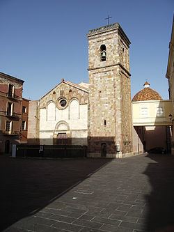
Santa Chiara Cathedral
The construction of the church of Santa Chiara was part of the initiatives aimed at demographic and urban development undertaken by the Donoratico della Gherardesca family.
It is not possible to attribute a single style to the church. Over the centuries it has been transformed several times, whether by the successive dominions or by restoration work (especially the restructuring that began in the nineteenth century). The façade has a pitched roof and is divided into two parts by a moulded cornice that runs horizontally at the level of the architrave over the doorway.
Inside, the church has a large single nave, with six side chapels and a cross-vaulted roof, supported on pillars with carved capitals. The bell tower is noteworthy, housing a bronze bell dating from 1337 by Andrea Pisano; the tower was plastered and the spire added in 1862.
The Museum of Sacred Art is located in the crypt of the Cathedral.
Church of San Francesco
The church has a gabled façade with smooth stonework; the door in the centre of the façade is surmounted by a rose window and flanked by two side oculi. It has a single nave with a wooden ceiling and is divided into seven bays, flanked by seven side chapels; these chapels and the presbytery were added from the sixteenth century onwards.The chapels all have simple cross vaulting meeting in a hanging pendant, except for the fifth chapel on the left, known as the “Crucifix” chapel. The stone choir replaces the original wooden choir which was demolished at the beginning of the 20th century. In addition to the marble font, there are interesting works of art in the chapels on the left, such as the retablo by Antioco Mainas.
The monastery, with the San Francesco Cloisters, was annexed to the church in the 16th century.
Church of Santa Maria di Valverde
The church stands outside the town walls, and is almost contemporary with the Cathedral, with similar style and structure.
Like the cathedral, it follows typical Romanesque style with some Gothic features. The façade underwent successive conservation and restoration works up until the twentieth century. Constructed from pink trachyte ashlars, it is divided into two parts by a horizontal moulded cornice. Inside is a single nave which originally had a lower wooden roof; it terminates in a large square presbytery area which is cross vaulted, with four hanging pendants. The central pendant, larger than the others, depicts the Madonna with Child.
Medieval fortifications
The so-called “Pisan” walls surround the city in correspondence with the historic centre and follow its irregular outline, making the most of the incline with the addition of Salvaterra castle. Although successive urban expansion led to several stretches of the walls being absorbed into private homes, the parts that can still be visited retain the solid, substantial features of medieval military fortifications: a series of blind façades constructed in mixed stones arranged in horizontal courses to create an uneven mass, guaranteeing strong resistance to attack.
Interrupted by 23 towers, the walls could only be passed through the four gateways: Porta Maestra, Porta Castello, Porta Sant'Antonio e Porta Nuova.
Town Hall
The building is in the heart of the historic town centre, in a central position as regards the original medieval perimeter walls. It was built by the Vincenzo Sulcis company between 1871 and 1872, according to plans by civil engineer Antonio Cao Pinna. The façade – set on a base of volcanic stone ashlars – is divided horizontally by string-course cornices. The Council meeting room is very interesting for the decorative additions carried out during the 1920s, designed by Francesco Ciusa, the Sardinian sculptor of international fame, and Remo Branca, the illustrator and painter. The artist Carmelo Floris created a triptych of pictorial panels which decorates the rear walls.
Sanctuary of Madonna delle Grazie
The current building of the Sanctuary of the Virgin delle Grazie dates back to between the 12th and 13th centuries and was initially dedicated to the Cagliari martyr San Saturno. The tastes of the various communitiesthat have modelled the building canbe seen in the façade. In the centre,it is the most ancient style that isevident – approximately 13th century.
Inside the church, there is a single nave divided into six bays by pointed trachyte arches supporting the wooden vault with exposed beams. Some apertures made in the thick outer walls simulate chapels, while two chapels stand out on either side of the presbytery, dedicated on the right to the Sacred Heart of Jesus and on the left to St. Francis.
Mining Art Museum
The Museum was conceived in 1998 by a group of “mining men” who wanted to create a tangible reminder of their origins, in order that the history of their land should not be forgotten.
It is housed in the basement of the “Giorgio Asproni” Mining Institute. On display are some scale model reproductions, newspaper articles about life in the mines and an important collection of period photographs. The museum also contains various types of machinery for the different phases of excavation, drilling and transport, as well as a reconstruction of a mechanical workshop and modern machinery. To reach the tunnels that run underneath the building, it is necessary to go down a ramp along a stretch of iron railway. Here, some of the phases of work in the mines have been reconstructed.
Historical Archive
The archive preserves the history of Villa di Chiesa, the ancient name for the town, from the Catalan-Aragonese, Spanish and Savoy periods. The series of documents begins with Il Breve di Villa di Chiesa, an ancient code of laws dating back to 1327.
It's written on a robust parchment, perhaps, as the text itself suggest, of mutton. Well preserved, only few pages are missing. The text is written in a neat Gothic script, in Pisan dialect.
The Breve is the result of a long process of legislative drafting that began during the period of Donoratico dominion and ended in the period of Aragon dominion. The definitive version, in four books, dates back to the period of direct rule by Pisa over Villa di Chiesa.
Flavia port
This construction holds an important position in terms of innovation and technology in the field of Sardinian mining construction.
The Belgian Vieille Montagne company appointed engineer Cesare Vecelli to carry out a planning study aimed at reducing the costs of transporting ore from the mine to the port. The project was carried out from 1922 to 1924. The construction runs entirely within the mountain for 600 metres (2,000 feet), before exiting high up above the sea. The external structure consists of a façade with a large arch beneath the inscription "Porto Flavia", flanked by a tower. The work consisted of excavating 9 bunkers inside the mountain by enlarging natural caverns. These 9 large rooms develop into two tunnels one on top of the other, directly opposite the islet known as Pan di Zucchero (Sugarloaf).
Monteponi mine
It is difficult to give a date for the first mining activity in this area. We know that Monte Paone was mentioned in 1324, in the will of Baron Berto da San Miniato, a trader from Pisa.
Over the years, th mining concession alternated between the State and private companies, without anyone being able to make it profitable. Poswitive results were finally achieved in 1850, when some entrepreneurs, led by Ligurian Paolo Antonio Nicolay, founded the Monteponi company to carry out mining work underground over thirty years, using the exsting structures. The settlement covers 4 levels and is a genuine worker’s village.
The 2008 project, by architects Herzog & de Meuron, planned to restore the entire industrial area for tourism and cultural purposes.
Saint Michele Church
Dating from the Aragon period, the church is linked to the Archfraternity of the Holy Virgin of Santo Monte. The only feature that distinguishes the façade from a secular building is the oculus with a moulded arched lintel. The interior consists of a small hall with a single nave, divided into two bays by a pointed arch. At the centre of the presbytery there is a stone table decorated with a relief depicting the Last Supper, and behind it is a niche with a statue of Saint Michael. To the right is the chapel dedicated to the Mysteries, built in 1727 to contain the processional statues for the different phases of the Passion. There is an interesting stone font, with four fish carved into the bowl, dating from the 16th to 17th centuries.
Saint Giuseppe Church
The church was built close to the church of Santa Lucia with the annexed hospital run by the Brothers. As Santa Lucia fell into disuse, the Sanctuary of San Giuseppe became the new site of the ancient Confraternity of Santa Lucia which later changed its name. The facade is simple: surmounted by a tympanum, it has an oculus in the centre with coloured glass forming the image of Saint Joseph with Child. Inside, the church has a single nave, with a vault of pointed arches. The presbytery area, with a square apse, has cross vaulting. There are two chapels at the sides with some interesting furnishings, including simulacra, such as the wooden niche.
Purissima Church
As the only example in Iglesias of Counter-Reformation architecture, the predominant feature of this church is the prefect correspondence between the interior and exterior. The harmony of the interior can be imagined from the facade, with its play of contrast between the white plaster and the red trachite. On the left is the bell tower, which still functions as the clock tower, having been restructured during the twentieth century. The interior has a large nave with three side chapels; the marble ornamentation is particularly noteworthy. The decorative features added after 1774, when the Jesuits left the city following the suppression of their Order, are in contrast with the general sobriety of the building. The paintings date back to the early years of the twentieth century, in fact. An exhibition on the Religious Architecture of Sulcis-Iglesiente has been mounted in the underground rooms of the complex.
Saint Domenico Church
The church is distinctive for the sobriety of the projecting features that decorate the façade, rather like embroidery. Framed by Corinthian columns and an architrave engraved with the Cannavera coat of arms, the majestic doorway can be attributed to Gothic-Catalan style. The building has a single nave with a barrel vault, divided into four spans by pointed arches. There are two chapels on each side, dedicated to the trade corporations that financed the work. The chapels on the right, added in 1910, differ from the original building in displaying the exposed rock. Among the more interesting decorations are four memorial tablets, including one dedicated to Bishop Nicolò Cannavera who built the church.
Saint Marcello Church
This church was the headquarters of the San Marcello brotherhood and was situated to the left of the Church of San Francesco until the end of the 19th century, when it was moved in order to make room for the new primary school. The reconstruction project was planned by engineer Luigi Degrossi in 1901, using some of the materials recovered from the original church, such as the slate slabs for the inside flooring. The neo-Gothic façade is all that remains to be admired of the original building. The red, sloping façade has a distinctive doorway with a pointed arch. At the cusp of the arch, a Greek orthodox cross directs the gaze up to the rose window above, while the top of the façade has a motif of small Gothic arches identical to those decorating the windows on the Bishop’s Palace.
Saint Antonio Abbot
This is one of the churches which dates back prior to the construction of the town itself (after 1258). Standing on a hill near the Cixerri valley, it would have been at the centre of a small village. The building, which has undergone much restructuring over time, has a simple facade with a gabled roof following a Byzantine-style plan. The facade gives an indication of the ancient structure of the monument, traces of which remain in the building to the right, now used as a sacristy: the neighbouring premises have absorbed one of the three naves which constituted the original building. Inside is a fairly small, quadrangular room with four pointed arches marking out four bays; it terminates in a large horseshoe-shaped apse.
Saint Salvatore Church
This is one of the churches dating back to before the city was built (after 1258) and is located outside the city walls. Comparison with the church of Santa Croce in Ittireddu enables us to date it to between the 9th and 10th centuries. It follows the structural layout of other churches of average size with a cruciform plan, built locally during the Byzantine empire, close to developing settlements. It is a simple building, with a sloping facade dominated by an arched doorway from which the weight is discharged into the external walls. The building is in the form of a Latin cross, with the nave crossing the transept and ending with signs of “toothing”, in correspondence with which a window now traces the shape of the ancient apse.
Saint Francesco Cloister
The church and monastery of San Francesco offer one of the most interesting and valuable testimonies left by the Friars Conventual Minor in Sardinia. The cloisters consisted of an open space surrounded by porticos on four sides. The monastery includes some wings developed according to the model of open loggias on the ground floor, arranged around a green area accessed through broad round arches in pink trachyte. Unfortunately, the lack of documentary sources and the damage suffered during the 1940s (when it was used as an air-raid shelter) make it impossible to be sure whether the cloisters that we see today are the same as the original ones. Following restoration work, it has now become possible to recover part of the original complex.
Monumental Cemetery
The cemetery covers the area between Via Cappuccini and Su Pardu, following a plan with intersecting avenues marking out squares. At the centre a stairway leads to the chapel on the principal avenue. Developed during the course of successive enlargements, the cemetery does not follow a ‘regulatory plan”, but certain aspects stand out, such as the avenue called the “Avenue of the Children”. The oldest nucleus is characterized by eclecticism, a style which has inspired the outer railings, funeral stones, urns, owls and angels flanking the stairway. The entrance from Via Cappuccini separates the sober Liberty-style flowers and obvious Masonic symbols on one side from the memorials dedicated to the war dead on the other. The sculptures by Giuseppe Sartorio are particularly noteworthy.
Piazza Sella
Piazza Sella is the centre of town life for Iglesias. It is a rest place where people can sit on benches and a pedestrian area where people can stroll around. It is bounded by Via Garibaldi, which leads to the railway station and separates it from the nearby Piazza Oberdan, by Via Valverde, and by Via Gramsci. It is well known as the site of the town market, another meeting place for the people of Iglesias. The Piazza is named after Quintino Sella because of the statue of Sella erected in the centre of the piazza in 1885; he is famous for having developed Iglesias as a mining town. The statue was sculpted by Giuseppe Sartorio, who was also responsible for the funeral sculptures in the Monumental Cemetery in Iglesias.
Piazza Oberdan
Opposite Piazza Sella is the Piazza named after Guglielmo Oberdan, with a War Memorial in the centre created in 1928 by Francesco Ciusa. The area bordering the piazza was used as a parking place for the few cars of the 1930s and ‘40s and also served as the Satas bus station. This place has always been used in Iglesias for military commemorations, from the gatherings and parades of the Fascist regime up to present day celebrations of national events. The renovation of Piazzetta Oberdan was proposed in April 1953, which involved laying pavement slabs, arranging flower-beds around the monument and fencing it off with chains.n In 1981 the whole piazza was re-surfaced and the flower-beds were re-arranged.
Saint Barbara Cave
Discovered in 1952. Some scholars estimate that it dates back to the Silurian age, between 444 and 416 million years ago. The itinerary lasts for about 3 hours and begins on the small train which runs along the ancient course of the mineral to a lift, which takes the visitor almost under the grotto. A spiral staircase leads into the interior. Consisting of a large elliptical room, with a diameter of 70m at the largest point and a height of 25m, the cave has imposing aragonite columns and calcareous formations of various shapes, and a 20 metre diameter lake. The cave is completely covered in concretions, and, of all the natural marvels it contains, mention must be made of the so-called “organ pipes”, calcareous formations which reproduce the sound of an organ when touched.
Cala Domestica Tower
The tower was built for defence against the Muslim invasions. The Spanish Crown had hundreds of towers and outposts built. This system was for both defence and counterattack: the towers equipped with canons would open fire, while the watch towers would send out smoke signals or drumbeat warnings. The tower was built as a lookout tower on the furthermost promontory of the stretch of coast between Portixeddu and Porto Paglia, above the entrance to the harbour, and it has a splendid view. The small fortress in the shape of a truncated cone was built in calcareous stone ashlars; it is 11metres high and has a diameter of about 12 metres. The doorway is about 6 metres high and leads into a single domed room about 7 metres wide, with 6 loopholes.
Mineralogical Museum
This museum was built in 1871 at the same time as the Mining School, to complete the miners’ theoretical training. It has two rooms with about 3000 items, constituting one of the most complete and valuable collections in the sector. The first room has samples from all over the world, including some striking original samples from the Paris basin. In addition to the mineral samples, there are examples of the tools used to extract them. The second room contains the main nucleus of the collection, with underground minerals, now no longer obtainable, from all over the region. The display cases are also fascinating, with grotesque and arabesque carvings and herms, fully embodying the aesthetic of functionality combined with Liberty elegance.
Museum Of Minerary Art
The Museum was conceived in 1998 by a group of “mining men” who wanted to create a tangible reminder of their origins, in order that the history of their land should not be forgotten. It is housed in the basement of the “Giorgio Asproni” Mining Institute. On display are some scale model reproductions, newspaper articles about life in the mines and an important collection of period photographs. The museum also contains various types of machinery for the different phases of excavation, drilling and transport, as well as a reconstruction of a mechanical workshop and modern machinery. To reach the tunnels that run underneath the building, it is necessary to go down a ramp along a stretch of iron railway. Here, some of the phases of work in the mines have been reconstructed.
Coastal territory, bays and beaches
In the littoral zone of the comune of Iglesias (8 kilometres (5.0 miles) from the centre of the city), starting from north to south, there are the following principal beaches:
Twin towns — Sister cities
Iglesias is twinned with:
Tourist Informations
Tourist Information: Piazza Municipio 1, Phone Number:+39 0781 274507, mail Address: [email protected]