
 | ||
The Iceland plume is a postulated upwelling of anomalously hot rock in the Earth's mantle beneath Iceland. Its origin is thought to lie deep in the mantle, perhaps at the boundary between the core and the mantle at approximately 2,880 km depth. Opinions differ as to whether seismic studies have imaged such a structure. In this framework, the volcanism of Iceland is attributed to this plume, according to the theory of W. Jason Morgan.
Contents
Geological history
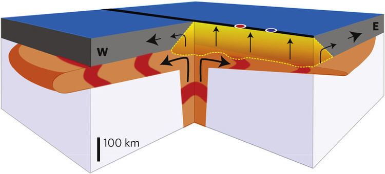
According to the plume model, the source of Icelandic volcanism lies deep beneath the center of the island. The earliest volcanic rocks attributed to the plume are found on both sides of the Atlantic. Their ages have been determined to lie between 58 and 64 million years. This coincides with the opening of the north Atlantic in the late Paleocene and early Eocene, which has led to suggestions that the arrival of the plume was linked to, and has perhaps contributed to, the breakup of the North Atlantic continent. In the framework of the plume hypothesis, the volcanism was caused by the flow of hot plume material initially beneath thick continental lithosphere and then beneath the lithosphere of the growing ocean basin as rifting proceeded. The exact position of the plume at that time is a matter of disagreement between scientists, as is whether the plume is thought to have ascended from the deep mantle only at that time or whether it is much older and also responsible for the old volcanism in northern Greenland, on Ellesmere Island, and at Alpha Ridge in the Arctic.
As the northern Atlantic opened to the east of Greenland during the Eocene, North America and Eurasia drifted apart; the Mid-Atlantic Ridge formed as an oceanic spreading center and a part of the submarine volcanic system of mid-oceanic ridges. The initial plume head may have been several thousand kilometers in diameter, and it erupted volcanic rocks on both sides of the present ocean basin to produce the North Atlantic Igneous Province. Upon further opening of the ocean and plate drift, the plume and the mid-Atlantic Ridge are postulated to have approached one another, and finally met. The excess magmatism that accompanied the transition from flood volcanism on Greenland, Ireland and Norway to present-day Icelandic activity was the result of ascent of the hot mantle source beneath progressively thinning lithosphere, according to the plume model, or a postulated unusually productive part of the mid-ocean ridge system. Some geologist have suggested that the Iceland plume could have been responsible for the Paleogene uplift of the Scandinavian Mountains by producing changes in the density of the lithosphere and asthenosphere during the opening of the North Atlantic.
An extinct ridge exists in western Iceland, leading to the theory that the plume has shifted east with time. The oldest crust of Iceland is more than 20 million years old and was formed at an old oceanic spreading center in the western fjord (Vestfirðir) region. The westward movement of the plates and the ridge above the plume and the strong thermal anomaly of the latter caused this old spreading center to cease 15 million years ago and lead to the formation of a new one in the area of today's peninsulas Skagi and Snæfellsnes; in the latter there is still some activity in the form of the Snæfellsjökull volcano. The spreading center, and hence the main activity, have shifted eastward again 7–9 million years ago and formed the current volcanic zones in the southwest (Reykjanes, Hofsjökull) and northeast (Tjörnes). Presently, a slow decrease of the activity in the northeast takes place, while the volcanic zone in the southeast (Katla, Vatnajökull), which was initiated 3 million years ago, develops. The reorganisation of the plate boundaries in Iceland has also been attributed to microplate tectonics.
Geophysical and geochemical observations
Information about the structure of Earth's deep interior can be acquired only indirectly by geophysical and geochemical methods. For the investigation of postulated plumes, gravimetric, geoid and in particular seismological methods along with geochemical analyses of erupted lavas have proven especially useful. Numerical models of the geodynamical processes attempt to merge these observations into a consistent general picture.
Seismology
An important method for imaging large-scale structures in Earth's interior is seismic tomography, by which the area under consideration is "illuminated" from all sides with seismic waves from earthquakes from as many different directions as possible; these waves are recorded with a network of seismometers. The size of the network is crucial for the extent of the region which can be imaged reliably. For the investigation of the Iceland Plume, both global and regional tomography have been used; in the former, the whole mantle is imaged at relatively low resolution using data from stations all over the world, whereas in the latter, a denser network only on Iceland images the mantle down to 400–450 km depth with higher resolution.
Regional studies from the 1990s and 2000s show that there is a low seismic-wave-speed anomaly beneath Iceland, but opinion is divided as to whether it continues deeper than the mantle transition zone at roughly 600 km depth. The velocities of seismic waves are reduced by up to 3% (P waves) and more than 4% (S waves), respectively. These values are consistent with a small percentage of partial melt, a high magnesium content of the mantle, or elevated temperature. It is not possible to unambiguously separate out which effect causes the observed velocity reduction.
Geochemistry
Numerous studies have addressed the geochemical signature of the lavas present on Iceland and in the north Atlantic. The resulting picture is consistent in several important respects. For instance, it is not contested that the source of the volcanism in the mantle is chemically and petrologically heterogeneous: it contains not only normal peridotite, but also eclogite — a fertile rock originating from subducted slabs — both of which contribute to the melts. The origin of the latter is assumed to be metamorphosed, very old oceanic crust which sank into the mantle several hundreds of millions of years ago during the subduction of an ocean, then upwelled from deep within the mantle.
Studies using the major and trace-element compositions of Icelandic volcanics showed that the source of present-day volcanism was about 100 °C greater than that of the source of mid-ocean ridge basalts.
The variations in the concentrations of trace elements such as helium, lead, strontium, neodymium, and others show clearly that Iceland is compositionally distinct from the rest of the north Atlantic. For instance, the ratio of He-3 and He-4 has a pronounced maximum on Iceland, which correlates well with geophysical anomalies, and the decrease of this and other geochemical signatures with increasing distance from Iceland indicate that the extent of the compositional anomaly reaches about 1,500 km along the Reykjanes Ridge and at least 300 km along the Kolbeinsey Ridge. Depending on which elements are considered and how large the area covered is, one can identify up to six different mantle components, which are not all present in any single location.
Furthermore, some studies show that the amount of water dissolved in mantle minerals is two to six times higher in the Iceland region than in undisturbed parts of the mid-oceanic ridges, where it is regarded to lie at about 150 parts per million. The presence of such a large amount of water in the source of the lavas would tend to lower its melting point and make it more productive for a given temperature.
Gravimetry/Geoid
The north Atlantic is characterized by strong, large-scale anomalies of the gravity field and the geoid. The geoid rises up to 70 m above the geodetic reference ellipsoid in an approximately circular area with a diameter of several hundred kilometers. In the context of the plume hypothesis, this has been explained by the dynamic effect of the upwelling plume which bulges up the surface of the Earth. Furthermore, the plume and the thickened crust cause a positive gravity anomaly of about 60 mGal (=0.0006 m/s²) (free-air).
Geodynamics
Since the mid-1990s several attempts have been made to explain the observations with numerical geodynamical models of mantle convection. The purpose of these calculations was, among other things, to resolve the paradox that a broad plume with a relatively low temperature anomaly is in better agreement with the observed crustal thickness, topography, and gravity than a thin, hot plume, which has been invoked to explain the seismological and geochemical observations. The most recent models prefer a plume that is 180–200 °C hotter than the surrounding mantle and has a stem with a radius of ca. 100 km. Such temperatures have not yet been confirmed by petrology, however.
Challenges to the plume model
The weak visibility of the postulated plume in tomographic images of the lower mantle and the geochemical evidence for eclogite in the mantle source have led to the theory that Iceland is not underlain by a mantle plume at all, but that the volcanism there results from processes related to plate tectonics and is restricted to the upper mantle.
Subducted ocean plate
According to one of those models, a large chunk of the subducted plate of a former ocean has survived in the uppermost mantle for several hundred million years, and its oceanic crust now causes excessive melt generation and the observed volcanism. This model, however, is not backed by dynamical calculations, nor is it exclusively required by the data, and it also leaves unanswered questions concerning the dynamical and chemical stability of such a body over that long period or the thermal effect of such massive melting.
Upper mantle convection
Another model proposes that the upwelling in the Iceland region is driven by lateral temperature gradients between the suboceanic mantle and the neighbouring Greenland craton and therefore also restricted to the upper 200–300 km of the mantle. However, this convection mechanism is probably not strong enough under the conditions prevailing in the north Atlantic, with respect to the spreading rate, and it does not offer a simple explanation for the observed geoid anomaly.