
Formed September 9, 1997 Fatalities None | Dissipated September 17, 1997 Highest winds 298 km/h | |
 | ||
Lowest pressure 902 mbar (hPa); 26.64 inHg(Second lowest in the Eastern Pacific) Damage $3.2 million (1997 USD) Date 9 September 1997 – 17 September 1997 Similar Hurricane Guillermo, Hurricane Nora, Hurricane Rick, Tropical Storm Ignacio, Tropical Storm Andres | ||
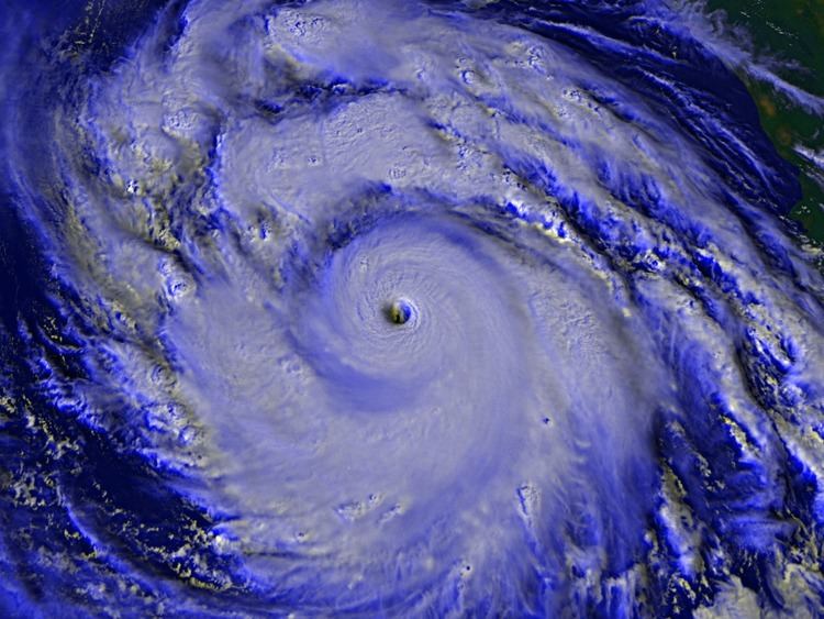
Hurricane linda 1997 most intense east pacific hurricane
Hurricane Linda was the second-strongest eastern Pacific hurricane on record. Forming from a tropical wave on September 9, 1997, Linda steadily intensified and reached hurricane status within 36 hours of developing. It rapidly intensified, reaching winds of 185 mph (295 km/h) and an estimated central pressure falling to 902 millibars (26.6 inHg); both were records for the eastern Pacific until Hurricane Patricia surpassed it in 2015. The hurricane was briefly forecast to move toward southern California, but instead, it turned out to sea and dissipated on September 17. It was the fifteenth tropical cyclone, thirteenth named storm, seventh hurricane, and fifth major hurricane of the 1997 Pacific hurricane season.
Contents
- Hurricane linda 1997 most intense east pacific hurricane
- Meteorological history
- Preparations and impact
- Records
- References
While near peak intensity, Hurricane Linda passed near Socorro Island, where it damaged meteorological instruments. The hurricane produced high waves along the southwestern Mexican coastline, forcing the closure of five ports. If Linda had made landfall on southern California as predicted, it would have been the strongest storm to do so since a storm in 1939. Though it did not hit the state, the hurricane produced light to moderate rainfall across the region, causing mudslides and flooding in the San Gorgonio Wilderness; two houses were destroyed and 77 others were damaged, and damage totaled $3.2 million (1997 USD, $4.3 million 2008 USD). Despite the intensity, the name was not retired.
Meteorological history
The origins of Hurricane Linda are believed to have been in a tropical wave that moved off the coast of Africa on August 24. The wave tracked westward across the Atlantic Ocean and Caribbean Sea without development. An area of convection developed to the west of Panama in the Pacific Ocean on September 6, which is believed to have been related to the tropical wave. The system continued westward, and within three days of entering the basin, a poorly defined circulation formed. Banding features began to develop, and at around 1200 UTC on September 9, the system organized into Tropical Depression Fourteen-E. At the time, it was approximately 460 miles (740 km) south of the Mexican city of Manzanillo.
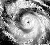
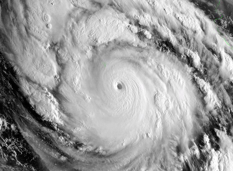
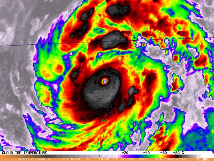
On becoming a tropical cyclone, the depression moved northwestward at 6 and 12 miles per hour (9.7 and 19.3 km/h), partially under the influence of a mid- to upper-level low near the southern tip of the Baja California peninsula. Deep convection and banding features increased, and the depression intensified into a tropical storm early on September 10. Upon being designated, the cyclone was named Linda by the National Hurricane Center (NHC). As upper-level outflow became well-established, the storm began to strengthen quickly. By September 11, an intermittent eye appeared, by which time the NHC estimated that Linda reached hurricane status. The storm began to rapidly intensify; its small eye became well-defined and surrounded by very cold convection. In a 24‑hour period, the minimum pressure dropped 81 millibars (2.4 inHg), or an average drop of 3.38 millibars (0.100 inHg) per hour. Such intensification met the criterion for explosive deepening, an average hourly pressure decrease of at least 2.5 millibars (0.074 inHg). By early September 12, Hurricane Linda reached Category 5 status on the Saffir-Simpson scale, and around 0600 UTC, Linda attained estimated peak winds of 185 mph (295 km/h) about 145 mi (235 km) southeast of Socorro Island. Its maximum sustained winds were estimated between 180 mph (285 km/h) and 195 mph (315 km/h), based on Dvorak T-numbers of 7.5 and 8.0 respectively, and gusts were estimated to have reached 220 mph (350 km/h). The hurricane's pressure is estimated at 902 millibars (26.6 inHg), making Linda the most intense Pacific hurricane at the time. When the storm was active, its pressure was estimated to have been slightly lower, at 900 millibars (27 inHg).
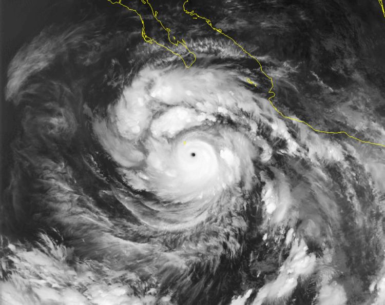
Shortly after reaching peak intensity, Hurricane Linda passed near Socorro Island as a Category 5 hurricane. Around that time, tropical cyclone forecast models suggested that the hurricane would turn toward southern California due to an approaching upper-level trough. Had Linda struck the state, it would have been much weaker at that time, possibly moving ashore as a tropical storm. Instead, Hurricane Linda turned west-northwestward away from land in response to a building ridge to the north of the hurricane. Despite remaining away from land, moisture from the storm reached southern California to produce rainfall. On September 14, the Hurricane Hunters and airplanes from National Oceanic and Atmospheric Administration investigated the hurricane to provide better data on the powerful hurricane. Hurricane Linda quickly deteriorated as it tracked toward cooler waters, weakening to tropical storm status on September 15. Two days later, when located about 1,105 miles (1,778 km) west of the southern tip of the Baja California peninsula, it weakened to tropical depression status. Linda no longer met the criteria for a tropical cyclone by September 18, although its remnant circulation persisted for a few more days before dissipating.
Forecasters and computer models did not anticipate how quickly Linda would strengthen; in one advisory, the NHC under-forecast how strong the winds would be in 72 hours by 115 miles per hour (185 km/h). The maximum potential intensity for Linda was 880 millibars (26 inHg), 22 millibars (0.65 inHg) lower than its actual intensity. The 1997 season was affected by the 1997-98 El Niño event, which brought warmer than normal water temperatures and contributed to the high intensity of several storms. Hurricane Linda occurred about a month after the similarly powerful Hurricane Guillermo, which also reached Category 5 status. The passage of Linda cooled the waters in the region, causing Hurricane Nora to weaken when it passed through the area on September 21.
Preparations and impact
Although the eye of Hurricane Linda did not make landfall, the hurricane passed near Socorro Island while near peak intensity. The hurricane cut power to wind and pressure instruments. A station on the island recorded a pressure of 986 millibars (29.1 inHg) before it stopped producing data. No tropical cyclone warnings or watches were issued for the hurricane. However, the threat for high tides and strong winds in Mexico prompted officials to issue coastal flood warnings and to close five ports. Waves of up to 7.8 feet (2.4 m) were reported along the coastline, causing flooding in the states of Michoacán, Jalisco, Nayarit, and Sinaloa.
When Linda was predicted to turn towards the northeast, it was forecast to move ashore in southern California as a weak tropical storm, which would have made Linda the first to do so since a tropical storm in 1939. The Oxnard, California National Weather Service office issued public information and special weather statements that discussed the possible impact of Linda on southern California. The advisories mentioned forecasting uncertainty, and advised the media not to exaggerate the storm. The office noted a threat for significant rainfall—possibly causing flash flooding—as well as high surf. To prepare for possible flooding, workers cleaned storm drains and prepared sandbags for coastal properties.
Although the storm did not make the turn, 15 and 18 feet (4.6 and 5.5 m) waves reached southern California. In Newport Beach, a wave swept five people off a jetty and carried them 900 feet (270 m) out to sea, although all were rescued by a passing boat. Moisture from the hurricane moved across the state, producing heavy rainfall and golfball-sized hail. A station in Forrest Falls, located within the San Gorgonio Wilderness, recorded rainfall rates of 2.5 inches (64 mm) per hour. The rainfall caused severe flooding and mudslides which destroyed two houses, damaged 77 others, and inflicted $3.2 million in damage (1997 USD, $4.3 million 2008 USD). San Diego recorded 0.05 inches (1.3 mm) of rain, the first measurable precipitation in 164 days; this tied the record for the longest duration without rainfall at the station, previously set in 1915 and 1924. Moisture from Linda extended into the Upper Midwest, contributing to a record daily rainfall total of 1.97 inches (50 mm) in Minneapolis, Minnesota.
Records
With an estimated pressure of 902 millibars (26.6 inHg), Hurricane Linda became the most intense Pacific hurricane since reliable records began in the 1966 season. Until Hurricane Patricia of 2015, Linda was also believed to have been the strongest since overall records began in the basin in 1949. The previous most intense hurricane was Hurricane Ava in 1973, which contained a confirmed pressure of 915 millibars (27.0 inHg). Since no observations recorded the pressure during Linda's peak, its peak intensity was estimated. As such, Ava remained the strongest measured hurricane in the basin at that time.