
Isolation 1.41 mi (2.27 km) Elevation 4,287 m | Easiest route Hike/scramble Prominence 361 m | |
 | ||
Topo map USGS 7.5' topographic mapCrestone Peak, Colorado Similar | ||
Humboldt Peak is a high mountain summit of the Crestones in the Sangre de Cristo Range of the Rocky Mountains of North America. The 14,070-foot (4,289 m) fourteener is located in the Sangre de Cristo Wilderness of San Isabel National Forest, 11.9 miles (19.2 km) south-southwest (bearing 204°) of the Town of Westcliffe in Custer County, Colorado, United States. The Crestones are a cluster of high summits in the Sangre de Cristo Range, comprising Crestone Peak, Crestone Needle, Kit Carson Peak, Challenger Point, Humboldt Peak, and Columbia Point.
Contents
Map of Humboldt Peak, Colorado 81252, USA
ClimbingEdit
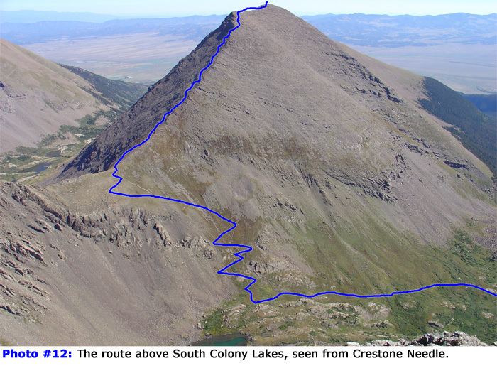
Humboldt Peak is the least challenging climb of the Crestones. The standard route on the peak is an exhausting hike along a trail, with rock scrambling (Class 2) near the summit. The trail climbs the peak from the South Colony Lakes basin, accessed from the east side of the range. This basin is a popular site that is also the base for most climbs of Crestone Peak and Crestone Needle. A very rugged four-wheel drive road follows the South Colony drainage to near the Lakes; however, this road will be closed halfway up on October 13, 2009. There is a lower parking lot for two-wheel drive access at the San Isabel National Forest boundary. The climb involves 4,464 feet (1,361 m) of elevation gain in a 14-mile (23 km) round trip when done from the two-wheel drive access point, but only 3,100 feet (940 m) of gain in a 6-mile (9.7 km) round trip from the current high-clearance four-wheel drive access point. As of 8/30/2007, 2WD lot has been moved back. From here climb involves 5,200 feet (1,600 m) of elevation gain in an 18-mile (29 km) round trip. When hiking Humboldt be sure to stay right on the ridge because the left is the north face and drops steeply.