
First contested 1988 District webpage profile, map District abolished 2013 | District created 1987 Last contested 2011 Population (2011) 71,563 Elector 59,797 | |
 | ||
Census divisions | ||
Humber—St. Barbe—Baie Verte was a federal electoral district in Newfoundland and Labrador, Canada, that had been represented in the Canadian House of Commons from 1988 to 2015.
Contents
Demographics
Ethnic groups: 96.2% White, 3.4% Native Canadian
Languages: 99.3% English
Religions: 73.8% Protestant, 23.2% Catholic, 2.1% No affiliation
Average income: $20 573
Humber—St. Barbe—Baie Verte is the riding with the highest percentage of people with English ethnic origin in all of Canada (46.8% - multiple responses).
Geography
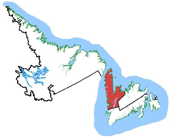
The district includes the Great Northern Peninsula, the Baie Verte Peninsula, the area along the southwest coast of Notre Dame Bay, the Bay of Islands, and the Corner Brook area. It also includes most of Glover Island, the Grey Islands (Groais Island and Bell Island), and the Horse Islands.
The neighbouring ridings are Labrador, Bonavista—Gander—Grand Falls—Windsor, and Random—Burin—St. George's.
According to Elections Canada, the geographic boundaries for the 39th General Election (2006) are:
"All that area consisting of that part of the Island of Newfoundland lying westerly and northerly of a line described as follows: commencing at a point midway between the towns of Triton and Leading Tickles in Notre Dame Bay; thence southerly in said bay to Seal Bay; thence southerly in a straight line to Frozen Ocean Lake at approximate latitude 49°11'N and approximate longitude 55°41'W; thence westerly in a straight line to Hinds Lake; thence southerly in a straight line to the mouth of Lloyds River at the westernmost extremity of Red Indian Lake; thence westerly in a straight line to Georges Lake; thence westerly in a straight line to Bluff Head on the eastern shoreline of Port au Port Bay. Including St. John Island, Quirpon Island, Sop's Island, Bell Island and Groais Island of the Grey Islands, Horse Islands and all other islands adjacent to the shoreline of the above-described area."See the map of the Humber—St. Barbe—Baie Verte riding (PDF).
History
The electoral district was created in 1987 from Grand Falls—White Bay—Labrador and Humber—Port au Port—St. Barbe. As of the 2012 federal electoral redistribution, this riding will be dissolved and divided between Long Range Mountains (80%) and Coast of Bays—Central—Notre Dame (20%).
Members of Parliament
This riding has elected the following Members of Parliament:
Previous elections
Canadian Alliance changes from 1997 are based on the results of its predecessor, the Reform Party.