
Country United States FIPS code 27-30392 Elevation 284 m Population 14,082 (2013) Area code 651 | Time zone Central (CST) (UTC-6) GNIS feature ID 0659709 Zip code 55038 Local time Thursday 1:26 AM | |
 | ||
Weather -6°C, Wind SE at 8 km/h, 69% Humidity Area 93.29 km² (86.64 km² Land / 6.656 km² Water) | ||
Hugo /ˈhjuːɡoʊ/ is a commuter town 21 miles (34 km) north of downtown Saint Paul in Washington County in the U.S. state of Minnesota. The population was 13,332 at the 2010 census. The city lies north of White Bear Lake on the border of the metropolitan boundary. Hugo and nearby suburbs comprise the northeast portion of Minneapolis-St. Paul, the sixteenth largest metropolitan area in the United States.
Contents
Map of Hugo, MN, USA
The city's largest lake, Oneka Lake, is named for the Dakota word "onakan," which means "to strike or knock off," rice into a canoe. Just south is Rice Lake where Mdewakanton Dakota from Mendota gathered wild rice.
History
Originally settled by French Canadians, Hugo early on established itself as a refueling station for the Lake Superior and Mississippi Railroad (later the Northern Pacific Railway). Located in Oneka township, the community was first named Centerville Station and finally Hugo. The present name is for Trevanion William Hugo, a mayor of Duluth. The village incorporated in 1906 and was officially incorporated as a city in 1972. After 2000, Hugo had absorbed significant suburban growth and development to become the thriving city it is today.
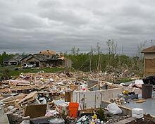
On May 25, 2008, an EF3 tornado struck the city.
Geography
According to the United States Census Bureau, the city has a total area of 36.02 square miles (93.29 km2); 33.45 square miles (86.64 km2) is land and 2.57 square miles (6.66 km2) is water.
The city is bound by Elmcrest Avenue North on its west, Keystone Avenue North on its east, 180th Street North on its north, and 120th Street North on its south. A major route within the city is U.S. Highway 61, which runs north–south. Interstate 35E is not within the city limits, but is heavily used by Hugo residents. It is located just west of Hugo. Washington County Road 8/Anoka County Road 14 connects U.S. 61 to Interstate 35E.
2010 census
As of the census of 2010, there were 13,332 people, 4,990 households, and 3,704 families residing in the city. The population density was 398.6 inhabitants per square mile (153.9/km2). There were 5,189 housing units at an average density of 155.1 per square mile (59.9/km2). The racial makeup of the city was 94.2% White, 0.7% African American, 0.3% Native American, 3.1% Asian, 0.6% from other races, and 1.0% from two or more races. Hispanic or Latino of any race were 2.2% of the population.
There were 4,990 households of which 40.4% had children under the age of 18 living with them, 60.8% were married couples living together, 9.2% had a female householder with no husband present, 4.2% had a male householder with no wife present, and 25.8% were non-families. 19.6% of all households were made up of individuals and 3.8% had someone living alone who was 65 years of age or older. The average household size was 2.67 and the average family size was 3.09.
The median age in the city was 33.7 years. 27.9% of residents were under the age of 18; 6.3% were between the ages of 18 and 24; 33.9% were from 25 to 44; 24.2% were from 45 to 64; and 7.8% were 65 years of age or older. The gender makeup of the city was 49.2% male and 50.8% female.
2000 census
As of the census of 2000, there were 6,363 people, 2,125 households, and 1,742 families residing in the city. The population density was 187.2 people per square mile (72.3/km²). There were 2,174 housing units at an average density of 64.0 per square mile (24.7/km²). The racial makeup of the city was 97.76% White, 0.18% African American, 0.42% Native American, 1.03% Asian, 0.05% Pacific Islander, 0.20% from other races, and 0.53% from two or more races. Hispanic or Latino of any race were 1.05% of the population.
There were 2,125 households out of which 45.1% had children under the age of 18 living with them, 71.5% were married couples living together, 6.7% had a female householder with no husband present, and 18.0% were non-families. 12.7% of all households were made up of individuals and 2.6% had someone living alone who was 65 years of age or older. The average household size was 2.99 and the average family size was 3.30.
In the city, the population was spread out with 31.3% under the age of 18, 6.5% from 18 to 24, 34.6% from 25 to 44, 22.7% from 45 to 64, and 4.9% who were 65 years of age or older. The median age was 34 years. For every 100 females there were 104.7 males. For every 100 females age 18 and over, there were 105.6 males.
The median income for a household in the city was $63,450, and the median income for a family was $65,222. Males had a median income of $44,069 versus $31,110 for females. The per capita income for the city was $24,334. About 1.4% of families and 1.5% of the population were below the poverty line, including 0.9% of those under age 18 and 6.1% of those age 65 or over.