
Length 71 mi (114 km) N/S Area 6,636 km² | Elevation 6,703 ft (2,043 m) Width 62 mi (100 km) E/W | |
 | ||
Mountains Cerro Alto Mountain, Packsaddle Mountain | ||
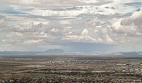
The Hueco Mountains are a range of mountains that rise in southern Otero County, New Mexico and extend twenty-seven miles south into Texas, generally along the El Paso–Hudspeth county line just east of the city of El Paso, Texas. The highest point of the range is the Cerro Alto Mountain (6,703 feet) in Hudspeth County.
Map of Hueco Mountains, Texas 79938, USA
The Hueco Bolson, a down-dropped area with an elevation of 4,000 feet above sea level, with sedimentary fill nearly 9,000 feet thick, lies between Hueco and Franklin Mountains. Shallow, stony soils in the Hueco Mountains support oak, juniper, and some mesquite. The mountains were part of the Rocky Mountain trend, forced upward as part of the Laramide mountain-building period during the late Cretaceous, 60 to 70 million years ago.
The word hueco is Spanish for hollow, gap, or hole.