
Peak Fuchshöhlenberg | Elevation 346 m | |
 | ||
Parent range Southwest Harz Foreland in the Weser-Leine Uplands | ||
The Hube is a ridge, up to 346.2 m above sea level (NN), in the Leine Uplands and district of Northeim, in the German state of Lower Saxony.
Contents
Map of Hube, 37574 Einbeck, Germany
GeographyEdit
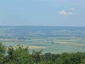
The densely wooded Hube lies immediately northeast of the town of Einbeck, with its pretty, timber-framed houses, west of the River Leine and north of the Ilme valley. Although the ridge, which measures some 8.5 x 5.5 kilometres, is west of the Leine it is counted as part of the southwestern Harz Foreland in Germany's official natural regional classification.
The highest elevation on the Hube is the Fuchshöhlenberg with its transmission mast at 346.2 m. About 150 metres southeast of the tower is the highest point of the actual summit. On the northern edge of the Greene Forest, the northern part of the Hube, are the ruins of Greene Castle above the town of Greene with good views from the castle tower. In the southern part of the Hube, 570 metres north of the Altendorfer Berg and between Einbeck and Negenborn stands the Emperor Frederick Tower (Kaiser-Friedrick-Turm), also called the Einbeck Tower (Einbecker Turm).
GeologyEdit
In the Hube region, carbonate rocks predominate. Upper and Middle Muschelkalk occur on its western rim, Lower Muschelkalk in the central area and Bunter Sandstone on its eastern slopes.
HillsEdit
The hills of the Hube, including its foothills, are (sorted by height in metres above sea level (NN):
SettlementsEdit
Settlements around the Hube whose built-up areas impinge significantly on the ridge are (sorted alphabetically):