
Country China Time zone China Standard (UTC+8) Local time Thursday 8:03 AM | Prefecture seat Tongren County Area 17,921 km² | |
 | ||
Weather -8°C, Wind S at 13 km/h, 75% Humidity | ||
Huangnan Tibetan Autonomous Prefecture (simplified Chinese: 黄南藏族自治州; traditional Chinese: 黃南藏族自治州; pinyin: Huángnán Zàngzú Zìzhìzhōu; Tibetan: རྨ་ལྷོ་བོད་རིགས་རང་སྐྱོང་ཁུལ་, Wylie: rma lho bod rigs rang skyong khul) is an autonomous prefecture of eastern Qinghai, China, bordering Gansu to the east. The prefecture has area of 17,921 km2 (6,919 sq mi) and its seat is in Tongren County.
Contents
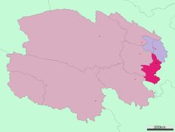
Map of Huangnan, Qinghai, China
Demographics
According to the 2000 census, Huangnan has 214,642 inhabitants with a population density of 11.98 inhabitants/km² (31.03 inhabitants/sq. mi.).
Subdivisions
The prefecture is subdivided into 4 county-level divisions: 3 counties and 1 autonomous county:
Rongwo Monastery
Huangnan is home to Rongwo Monastery, a Gelug monastery initially established in 1341 in Amdo on the Rongwo River.
References
Huangnan Tibetan Autonomous Prefecture Wikipedia(Text) CC BY-SA