
Country United States Type of dam Concrete thin arch Length 660 ft (200 m) Opened 1927 Create Apache Lake | Opening date 1927 Height 93 m Catchment area 15,131 km² Construction began 1924 | |
 | ||
Owner United States Bureau of Reclamation Similar Mormon Flat Dam, Stewart Mountain Dam, Bartlett Dam, Salome Wilderness, Salt River | ||
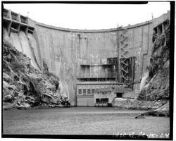
The Horse Mesa Dam is a concrete thin arch dam located in the Superstition Mountains, northeast of Phoenix in Maricopa County, Arizona.
Contents
Map of Horse Mesa Dam, Apache Junction, AZ 85119, USA
The dam is 660 feet (200 m) long, 300 feet (91 m) high and was built between 1924-27. The dam includes three conventional hydroelectric generating units totaling 32 megawatts (MW) and a pumped-storage unit with a capacity of 97 MW.
Reservoir
The dam forms Apache Lake as it impounds the Salt River. The dam and reservoir are located downstream from the Theodore Roosevelt Dam, and upstream from the Mormon Flat Dam.
References
Horse Mesa Dam Wikipedia(Text) CC BY-SA