
Country Germany District Saar-Palatinate Time zone CET/CEST (UTC+1/+2) Population 43,691 (31 Dec 2008) | State Saarland Elevation 233 m (764 ft) Postal codes 66424 (66401–66424) Local time Monday 11:16 PM | |
 | ||
Weather 6°C, Wind N at 6 km/h, 77% Humidity Points of interest Schlossberghöhlen, Römermuseum Schwarzenacker, Burgruine Hohenburg, Karlsberg Castle, Biotop Beeden | ||
Homburg ( [ˈhɔmbʊʁk]) is a town in Saarland, Germany, the administrative seat of the Saar-Palatinate district. With a population of c. 41,974 inhabitants (December 31st 2015), is the third city in its federal state. The medical department of the University of Saarland is situated here. The city is also home to the Karlsberg beer brewery. Major employers include Michelin and Robert Bosch GmbH.
Contents
- Map of Homburg Germany
- Geography
- History
- Main sights
- Transport
- Personalities
- International relations
- References
Map of Homburg, Germany
Geography
Homburg is situated in north of the district of Saar-Palatinate, close to the borders of Saarland with Rhineland-Palatinate and not too far from France. It is 16 km from Neunkirchen and 36 km from Saarbrücken.
The town counts 9 villages: Beeden, Bruchhof-Sanddorf, Einöd, Erbach, Jägersburg, Kirrberg, Reiskirchen, Schwarzenbach and Wörschweiler.
History
The Hohenburg Castle, nowadays a ruin, was in the 12th Century the seat of the counts of Homburg. In 1330 the village received the town status (Stadtrecht) by Louis the Bavarian.
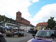
Main sights
Transport
Homburg (Saar) Hauptbahnhof is the main railway station in the town, served by long-distance and regional trains. By road transport, the town is served by the motorways A6 (exit Homburg) and A8 (exits Limbach and Einöd).
Personalities
International relations
Homburg is twinned with: