
 | ||
The Holdridge life zones system is a global bioclimatic scheme for the classification of land areas. It was first published by Leslie Holdridge in 1947, and updated in 1967. It is a relatively simple system based on few empirical data, giving objective mapping criteria. A basic assumption of the system is that both soil and climax vegetation can be mapped once climate is known.
Contents
Scheme
While it was first designed for tropical and subtropical areas, the system applies globally. The system has been shown to fit tropical vegetation zones, Mediterranean zones, and boreal zones, but is less applicable to cold oceanic or cold arid climates where moisture becomes the determining factor. The system has found a major use in assessing the possible changes in natural vegetation patterns due to global warming.
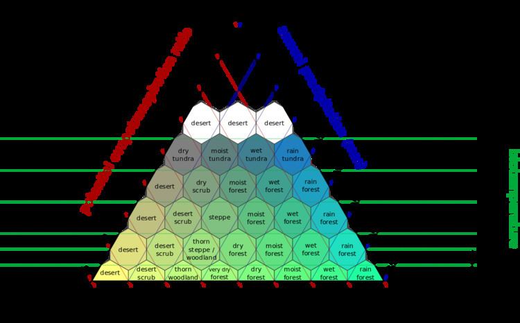
The three axes of the barycentric subdivisions are:
Further indicators incorporated into the system are:
Biotemperature is based on the growing season length and temperature. It is measured as the mean of all temperatures above freezing, with all temperatures below freezing and above 30 °C adjusted to 0 °C, as plants are dormant at these temperatures. Holdridge's system uses biotemperature first, rather than the temperate latitude bias of Merriam's life zones, and does not primarily consider elevation. The system is considered more appropriate to the complexities of tropical vegetation than Merriam's system.
Scientific Relationship between the 3 axes and 3 indicators
Potential evapotranspiration (PET) is the amount of water that would be evaporated and transpired if there were sufficient water available. High temperatures result in higher PET. Evapotranspiration (ET) is the sum of evaporation and plant transpiration from the Earth's land surface to atmosphere. Evapotranspiration can never be greater than PET. The ratio, Precipitation/PET, is the aridity index (AI), with an AI<0.2 indicating arid/hyperarid, and AI<0.5 indicating dry.
Coldest / / PET - -- - RainColdest regions have not much evapotranspiration nor precipitation, hence polar deserts. In the warmer regions, there are deserts with maximum PET but low rainfall that make the soil even drier, and rain forests with low PET and maximum rainfall causing river systems to drain excess water into oceans.
Classes
The classes defined within the system, as used by the International Institute for Applied Systems Analysis (IIASA), are: