
Elevation 334 m (1,096 ft) Area 63.79 km² Local time Monday 9:03 AM | Time zone CET/CEST (UTC+1/+2) Population 6,178 (30 Jun 2009) Administrative region Darmstadt | |
 | ||
Weather 4°C, Wind SE at 8 km/h, 65% Humidity | ||
Hohenstein is a community in the Rheingau-Taunus-Kreis in the Regierungsbezirk of Darmstadt in Hesse, Germany.
Contents
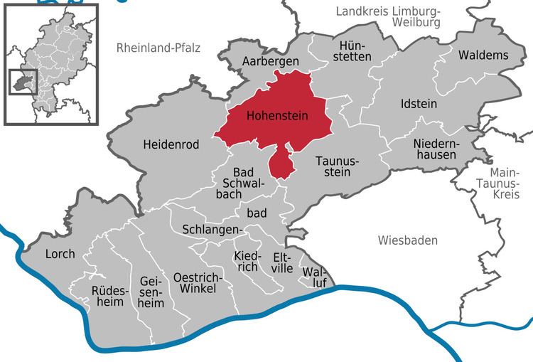
- Map of 65329 Hohenstein Germany
- Location
- Neighbouring communities
- Constituent communities
- History
- Community council
- Buildings
- Regular events
- Economy and infrastructure
- Transport
- Education
- References
Map of 65329 Hohenstein, Germany
Location
Hohenstein lies in the western Taunus, on both sides of the river Aar between Limburg and Wiesbaden.
Neighbouring communities
Hohenstein borders in the north on the community of Aarbergen, in the northeast on the community of Hünstetten, in the east and south on the town of Taunusstein, in the southwest on the town of Bad Schwalbach, and in the west on the community of Heidenrod (all in the Rheingau-Taunus-Kreis).
Constituent communities
Hohenstein’s Ortsteile are Breithardt (administrative seat), Burg-Hohenstein, Holzhausen über Aar, Strinz-Margarethä, Born, Hennethal and Steckenroth.
History
In 1184, Strinz-Margarethä had its first documentary mention, making it the earliest of Hohenstein’s constituent communities to have its name appear in the historical record. The other centres followed in the 13th and 14th centuries.
In the course of municipal reform in Hesse, the current greater community of Hohenstein was founded out of the formerly self-governing communities of Breithardt, Hohenstein, Holzhausen über Aar, Strinz-Margarethä, Born, Hennethal and Steckenroth on 1 July 1972. The constituent community of Hohenstein was thereafter known as Burg-Hohenstein (Burg means “castle” in German).
Community council
The municipal election held on 26 March 2006 yielded the following results:
Buildings
Regular events
Economy and infrastructure
The centres in the community, whose livelihood was once based on agriculture, have built themselves into residential communities. There are the usual trades and businesses in Hohenstein, but no true industry.
Transport
Hohenstein lies on Bundesstraße 54 between Wiesbaden and Limburg.
Education
In the constituent community of Breithardt is a primary school. The nearest comprehensive schools are to be found in Aarbergen and Taunusstein. The latter offers a Gymnasium upper level. The nearest Gymnasium is likewise to be found in Taunusstein.