
Prominence 663 m | Elevation 2,610 m | |
 | ||
First ascent Prince-Bishop Schwarzenberg with Gemminger, Tatz and Wein, 1830 Easiest route From the Ofen valley, grade I; normal route: over the "Schönen Fleck" from the Blaueishütte, grade II Similar Watzmann, Hoher Göll, Großer Hundstod, Hohes Brett, Jenner | ||
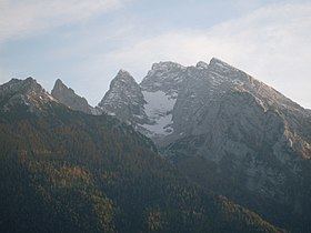
At 2,606.9 metres (8,553 ft), the Hochkalter in the Berchtesgaden Alps is the highest peak in the massif of the same name and therefore one of the highest mountains in Germany. The Hochkalter Massif (German: Hochkalterstock or Hochkaltermassiv) is also called the Hochkalter mountains (German: Hochkaltergebirge).
Contents
- Map of Hochkalter 83486 Ramsau bei Berchtesgaden Germany
- Geology of the Hochkalter mountains
- Rockfalls
- Overview of the Hochkalter summits
- References
Map of Hochkalter, 83486 Ramsau bei Berchtesgaden, Germany
The Hochkalter massif lies west of the Watzmann massif and, like it, is located within the Berchtesgaden National Park. The Hochkalter mountains are divided into sub-groups known as the Hochkalter Group (Hochkalter-Gruppe), Hocheis Group (Hocheis-Gruppe) and Southern Wimbach Chain (Südliche Wimbachkette). The most important base for climbing this alpenstock is the German Alpine Club's Blaueis Hut (Blaueishütte, literally "Blue Ice Hut") which lies at a height of 1,653 metres (5,423 ft) in the Blaueis Cirque (Blaueiskar) below the Blaueis, the most northern glacier in the Alps. Other mountain huts are the Bergheim Hirschbichl for the Hocheis Group, the Wimbachgries Hut (Wimbachgrieshütte) for climbs up the eastern flanks of the massif and the Ingolstädter Haus for the Southern Wimbach Chain.
Geology of the Hochkalter mountains
The Hochkalter mountains, like the entire Northern Limestone Alps, consist of a mixture of dolomite and limestone. In the Hochkalter and Hocheis Groups, the harder Dachstein limestone predominates, rock that was formed by sedimentation in the Tethys Ocean during the Late Triassic stage (220 million years ago). When the Alps were formed the sloping strata of Dachstein limestome were tipped at an angle of 30° to 40° by tectonic movements of the African and European continental plates. The result can be clearly seen on the Hochkalter massif especially in the Ofen valley (Ofental). Much of the Southern Wimbach Chain comprises brittle Ramsau dolomite, which has contributed significantly to the accumulation of rocks in the Wimbach valley.
Rockfalls
Large rockfalls occurred time and again on the Hochkalter massif. In prehistoric times – around 3,500 years ago – more than 15 million m³ of rock slid from the upper Blaueis Combe into the valley. These rockslides impounded the lake of Hintersee. Even today the large glacial erratics in the Zauber Forest bear witness to this monumental event. But even in recent times there have frequently been large rock-falls:
The brittleness of the rock in the Wimbach valley is very obvious. The floor of the valley is covered by streams of debris of great depth. This magnificent landscape may be experienced by anyone who walks from Ramsau (Wimbach Bridge car park) along the valley, initially through the Wimbach Gorge and then onto the open valley floor (about one hour to the Wimbachschloss Inn, a further hour to the Wimbachgries Hut, 1,327 m).