
 | ||
The state highway system in the U.S. state of California dates back to 1896, when the state took over maintenance of the Lake Tahoe Wagon Road. Construction of a large connected system began in 1912, after the state's voters approved an $18 million bond issue for over 3000 miles (4900 km) of highways. The last large addition was made by the California State Assembly in 1959, after which only minor changes have been made.
Contents
1895 to 1919
The first state road was authorized on March 26, 1895, when a law created the post of "Lake Tahoe Wagon Road Commissioner" to maintain the Lake Tahoe Wagon Road (the 1852 Johnson's Cut-off of the California Trail), now US 50 from Smith Flat - 3 miles (5 km) east of Placerville - to the Nevada state line. The 58 mile (93 km) road had been operated as a toll road until 1886, when El Dorado County bought it; the county deeded the road to the state on February 28, 1896. Funding was only enough for minimal improvements, including a stone bridge over the South Fork American River in 1901.
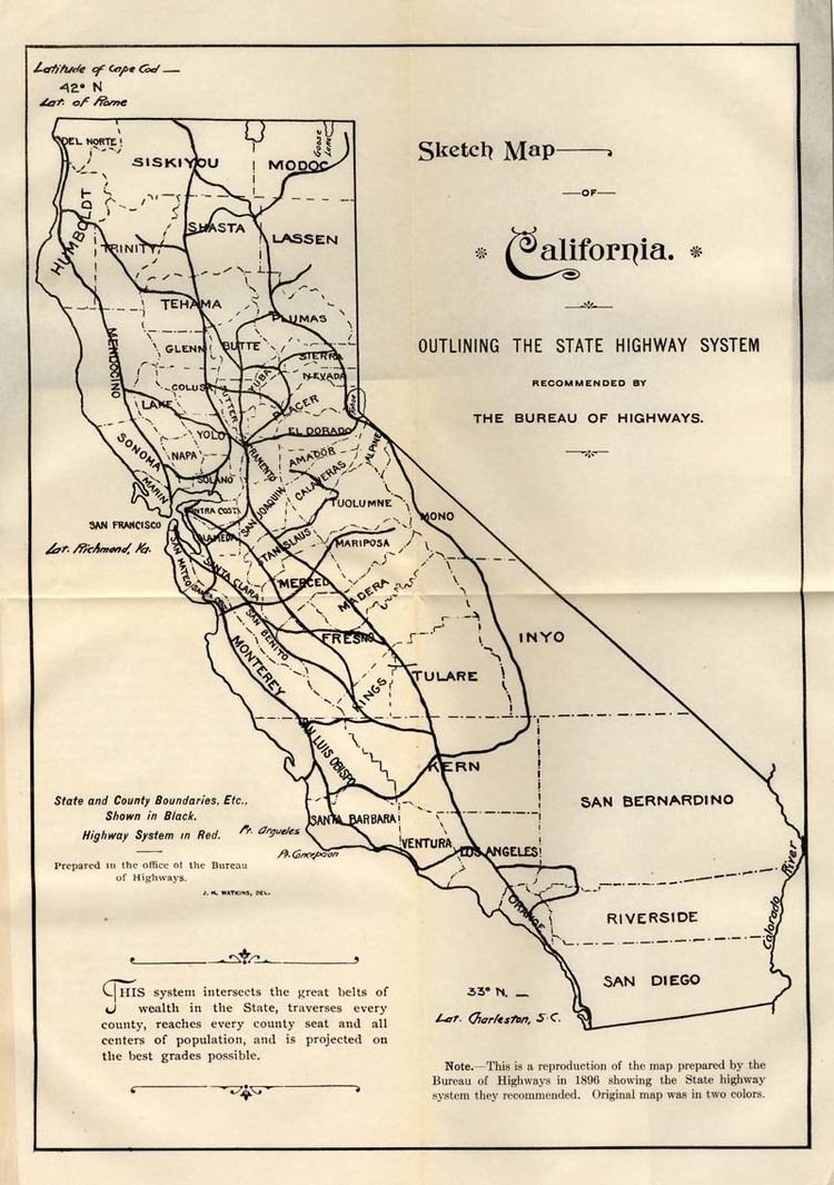
Also in 1895, on March 27, the legislature created the three-person Bureau of Highways to coordinate efforts by the counties to build good roads. The bureau traveled to every county of the state in 1895 and 1896 and prepared a map of a recommended system of state roads, which they submitted to the governor on November 25, 1896. The legislature replaced the Bureau of Highways with the Department of Highways on April 1, 1897, three days after it passed a law creating a second state highway from Sacramento to Folsom - another part of what became US 50 - to be maintained by three "Folsom Highway Commissioners". This was the last highway maintained by a separate authority, as the next state road, the Mono Lake Basin State Road (now part of SR 120), was designated by the legislature in 1899 to be built and maintained by the Department of Highways.
Several more state highways were legislated in the next decade, and the legislature passed a law creating the Department of Engineering on March 11, 1907. This new department, in addition to non-highway duties, was to maintain all state highways, including the Lake Tahoe Wagon Road. On March 22, 1909 the "State Highways Act" was passed, taking effect on December 31, 1910 after a successful vote by the people of the state in November. This law authorized the Department of Engineering to issue $18 million in bonds for a "continuous and connected state highway system" that would connect all county seats. To this end, the department created the three-member California Highway Commission on August 8, 1911 to take full charge of the construction and maintenance of this system. As with the 1896 plan by the Bureau of Highways, the Highway Commission traveled the state to determine the best routes, which ended up stretching about 3100 miles (5000 km). Construction began in mid-1912, with groundbreaking on Contract One - now part of SR 82 in San Mateo County - on August 7. Noteworthy portions of the system built by the commission included the Ridge Route in southern California and the Yolo Causeway west from Sacramento.
Because the first bond issue did not provide enough funding, the "State Highways Act of 1915" was approved by the legislature on May 20, 1915 and the voters in November 1916, taking effect on December 31. This gave the Department of Engineering an additional $12 million to complete the original system and $3 million for a further approximately 680 miles (1100 km) specified by the law. At this time, each route was assigned a number from 1 to 34; this system of labeling routes, although never marked with signs, remained until the 1964 renumbering. In 1917, the legislature gave the California Highway Commission statutory recognition, and turned over the approximately 750 miles (1200 km) of roads adopted by legislative act, until then maintained by the State Engineer, to the commission. Where not serving as extensions of existing routes, these - and routes subsequently added legislatively in 1917 and 1919 - were given numbers from 35 to 45. A third bond issue was approved by the voters at a special election on July 1, 1919, and provided $20 million more for the existing routes and the same amount for new extensions totaling about 1800 miles (2900 km), adding Routes 46 to 64 to the system. The three bond issues together totaled 5560 miles (8948 km), of which just over 40% (60% if the 1919 bond issue is left out) was completed or under construction in mid-1920.
1920 to 1958
The Department of Engineering became part of the new Department of Public Works in 1921, and the California Highway Commission was entirely separated as its own department in 1923. In order to pay for the roads, a 2-cent per gallon gasoline tax was approved in 1923. The legislature continued to add highways to the system, including the Mother Lode Highway (now part of SR 49) in 1921 and the Arrowhead Trail (now I-15 north of Barstow) in 1925. In January 1928, the California State Automobile Association and Automobile Club of Southern California, which had already been placing guide and warning signs along state highways, marked the U.S. Highways along several of the most major state highways. The California Toll Bridge Authority was created in 1929 to acquire and operate all toll bridges on state highways, including the San Francisco–Oakland Bay Bridge and Carquinez Bridge.
After 1927 and 1929, in which no highways were added to the system, the legislature authorized the construction of 23 new routes in 1931, which were numbered from 72 to 80 when not forming extensions of existing routes. Two years later, another 213 sections of highway were added, almost doubling the total length of state highways to about 14000 miles (23000 km); the last-assigned route number jumped from 80 to 202. Many of these new routes, as well as a number of existing routes, were incorporated into the initial system of state sign routes in 1934, also posted by the auto clubs.
The Division of Highways took over signage on state highways from the auto clubs in 1947, though at least the Auto Club of Southern California continued to place signs on city streets until 1956.
The "Great Renumbering" of 1964
In 1963 and 1964, the California Division of Highways implemented a major renumbering of its state highways. The majority of sign routes — those marked for the public — kept their numbers; the main changes were to the legislative routes, which had their numbers changed to match the sign routes. A large number of formerly unsigned routes received sign numbers corresponding to their new legislative numbers. A smaller change was the removal and truncating of many U.S. Routes in favor of the Interstate Highways (designated in 1959), and the renumbering of State Routes that conflicted with Interstate numbers. Some U.S. Routes that were officially removed continued to be signed until the replacement Interstates were completed. The state law authorizing the renumbering was passed on September 20, 1963. Signage changes took place by July 1, 1964.
1964 to present
A regularly recurring issue in California politics since the 1960s is whether the state should continue to aggressively expand its freeway network or concentrate on improving mass transit networks. Freeway revolts sprang up across the state in the 1960s and 1970s, killing or delaying several projects such as a freeway in San Francisco between the Golden Gate Bridge and the San Francisco–Oakland Bay Bridge, and an expansion of Interstate 710 through South Pasadena.
Both the National Environmental Policy Act of 1969 and the California Environmental Quality Act of 1970 added significant environmental regulations to highway construction. Then in 1972, the Department of Public Works was merged with the Department of Aeronautics to become the modern California Department of Transportation (Caltrans). Now Caltrans not only manages the state highway system, but is also actively involved with public transportation systems throughout the state, and thus is essentially in charge of the entire state's transportation network.
Toll roads and high-occupancy toll lanes began to open across the state beginning in the 1990s. The decade also saw the implementation of FasTrak, California's electronic toll collection (ETC) system, across all toll facilities on state highways. The 91 Express Lanes opened in 1995 along State Route 91 between Anaheim and the Riverside County line, developed as a partnership between Caltrans and the private California Private Transportation Company (CPTC). The Transportation Corridor Agencies, a local agency created by the state, also established three toll roads in Orange California in the 1990s. Another privately financed toll highway project, the South Bay Expressway, began operation in San Diego County in 2007. Several other HOT lanes across various state highway are also either currently under construction or in the planning stages.