
Topo map USGS Hines Peak Elevation 2,047 m | Easiest route Hike | |
 | ||
Similar Antimony Peak, Burnt Peak, Eagle Rest Peak, Cobblestone Mountain, Big Pine Mountain | ||
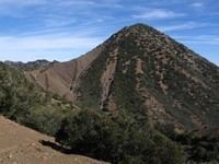
Hines Peak is the highest peak of the Topatopa Mountains, at 6,716 feet (2,047 m).
Map of Hines Peak, California 93060, USA
It is located within the Ventura County section of Los Padres National Forest, several miles northeast of Santa Paula. Snow falls on the mountain during the winter months.
References
Hines Peak Wikipedia(Text) CC BY-SA