
 | ||
Highways in Poland are public roads which are grouped into four categories related to the republic's administrative division. Motorways and expressways are part of the national road network. Voivodeship roads are provincial-level roads administered by the individual governments of the voivodeships. Powiat and gmina roads are administered by county and municipal authorities, and do not have any separate road signs for them. Poland has 412,264 km (256,169 mi) of public roads, of which 131,863 km (81,936 mi) are unsurfaced (2011):
Contents
- Definitions of highways according to Polish law
- Technical parameters
- Tolls
- Open system
- Closed system
- Free motorways
- viaTOLL payment system
- Planned Electronical Toll Collection System
- List of Polish motorways and expressways
- Before World War II
- Situation
- Plans
- In the 1970s
- In the 1980s
- In the 1990s
- Before Poland received the EU membership
- Poland in EU
- Total length of highways in Poland end of the year
- References
As of 10 January 2016, there are 3,274.67 km (2,034.79 mi) of motorways (autostrady, singular - autostrada) and expressways (drogi ekspresowe, singular - droga ekspresowa) in use.
Definitions of highways according to Polish law
The law of 21 March 1985 law about the public roads, with later amendments, defines the motorways and expressways as follows:
Technical parameters
The parameters of these roads are determined by the Ordinance of the Minister of Transport and Maritime Economy of 2 March 1999 - on technical parameters to be met by public roads and their location. Expressways are different from motorways mainly in that they:
- Can have a single carriageway
- Motorways can have interchanges only with main roads. The spacing between nodes should not be less than 15 km, and within borders or near a big city or a group of cities not less than 5 km. In exceptional cases, if necessary for the functional traffic movement, it can be not less than 3 km, but only within or near a large city or in a group of cities. Expressways may have them more often.
- Sometimes have a junction in built-up areas(motorways try to avoid it)
- Is designated for lower speed that the motorway
- Have narrower lanes(emergency lanes can be narrower, too, and they needn't be present at all). Motorways, on the other hand, must have them.
- Expressways have narrower road width (with all structures beside it) than motorways have - 40 m versus 60 m in motorways
- Expressways may built as the upgrade of the national road (voivodership road only in S61). However, most modern projects are built(planned) as a separate road rather than just as an addition of the lanes to the existing one(like S3). Motorways can't be built as the national road upgrade but as a separate road only
Other parameters of the roads:
Tolls
At the moment cars are free of payment while driving on expressways, however A1, A2 and A4 are planned as tolled(some parts are already such). The payments from motorways are coming to the National Roads Fund.
The National Roads Fund pays out money, if the amount of income received by the private concessor is less than was expected by the agreement between the government and the concessor. For example, in 2012 33 million PLN was allocated to private companies because of that.
There are two systems to collect money:
Open system
Open system is more popular among the private concessors, where money is paid only in the toll booths put across the roads. There different amount of money is paid according to the type of the vehicle. It is relatively cheap, but it forces drivers to stop at each toll booth, and so lowers the capacity of the motorway. For example, in the Greater Poland part of A2 the distance between booths is approx. 50 km.
There are 3 parts of motorways where this system is in force:
Autostrada Eksploatacja S.A. on motorway A2 serves it on the sections:
Stalexport Autostrada Malopolska S.A. built the first toll system in Poland, which was opened on 3.04.2000 on the Mysłowice-Brzęczkowice – Balice I(61 km) section.
Closed system
Another way to collect money from motorway using is so-called closed system, on which there are toll stations on every interchange both entering and exiting the motorway, as well as toll booths on the motorway, which signifies the end of the concession section. In this case the driver receives a ticket while entering the motorway, which must be kept all the time using the motorway. He pays at either toll station while exiting the motorway or at the toll booth. The amount of money depends not only on the type of the car, but also on the distance driven. It is more expensive at the building and maintenance, as the toll stations have to be built at every interchange. However, it requires fewer toll booths across the motorway, which is a big advantage, as the traffic is free-flowing, and there is less fuel consumption. The queues before the tolls are put off the motorway, and are put onto the exits and interchanges.
Next sections take the tolls in such a way:
- Motorway A1:
- Autostrada A2:
- Autostrada A4:
Free motorways
The motorways that are toll-free at the moment:
viaTOLL payment system
From 1.07.2011 all vehicles weighing more than 3.5 tons are obliged to have a special viaTOLL apparatus. On the chosen roads the special electronic readers are installed. They connect to the apparatus in the vehicle in a wireless way, and they also count the toll the vehicle has to pay. It is possible to buy it on some petrol stations or at the special points of selling. If the apparatus isn't at the place, fines are applied:
Planned Electronical Toll Collection System
In 2014 the Ministry of Infrastructure and Development has uncovered the plans to imply the Electronical Toll Collection System. The new plans were made because of the big problems concerning the Manual Toll Collection System. At the time while there is a huge flow of traffic(especially in the holiday period), there are long queues to the toll booths, which, according to some reports, reached up to 10 km. Drivers in these cases are forced to wait 2 hours to pay the toll at the toll booths. That was the reason the works to construct the toll booths on A4 were suspended, even though there were some stages of construction in progress.
The situation wasn't much relieved even after the toll booths had separated a special lane for those vehicles that have been registered into the ViaAuto system. It came out even worse. A lot of experts tell it is one lane less for those paying traditionally.
At those times a few simple solutions were introduced, for example the cashiers themselves giving the tickets. Next solution came from the Council of Ministers, which claimed that the motorway will be free from the day they gave out the decision(06.08.2014) to the end of the summer holidays(it only concerned the period from 4.00 p.m. on Friday to midnight from Sunday to Monday).
Now the ministry is working on the system, that is planned to be introduced somewhere in 2016-2017. According to different concepts, there are two options - either the full liquidation of the toll booths or their reconstruction. The reconstructed toll booths had then the toll applied via the viaTOLL system, so every vehicle must have had the viaTOLL apparatus, as the cars and trucks heavier than 3.5 tons have. Taking into account that not every driver drives regularly on the motorway, there must have been an online registration for light cars introduced. After that, when any car would arrive to such a toll booth, the registration plate will be scanned, and so the car would be recognized. However, before that implication the system must be first agreed with the private concessors.
List of Polish motorways and expressways
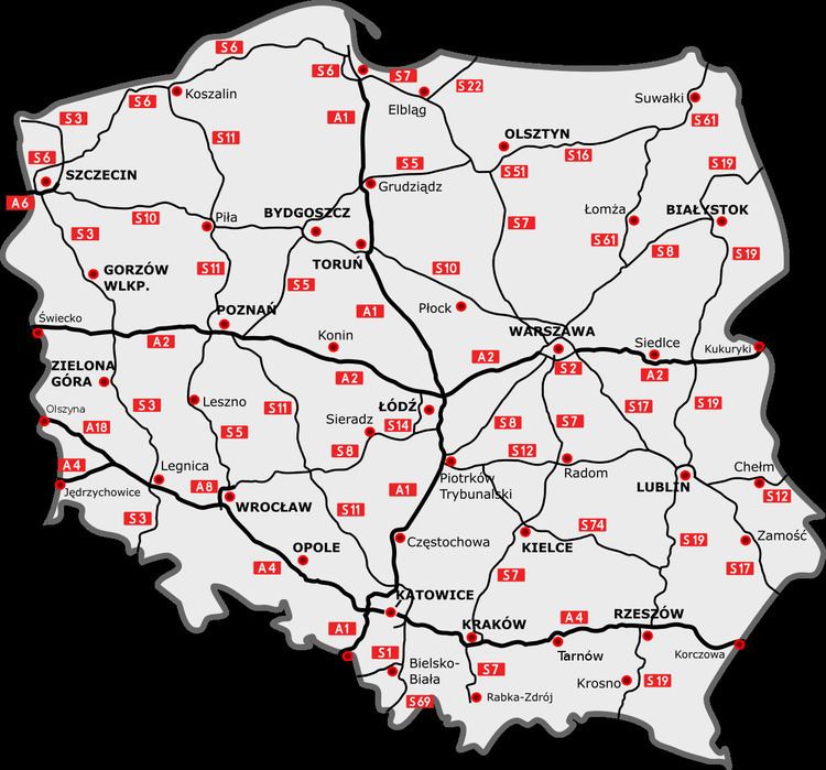
Motorways in Poland are identified by the letter A, followed by a number (e.g. A1). Under current plans, by 2022 three motorways will span the country, with two routes running along an east to west axis (A2 running centrally and A4 running southerly) and one motorway traversing a north to south axis (with A1 running centrally). In addition, three shorter motorway stretches (A6, A8, A18) complete the planned motorway network. The only complete motorway stretches are A4 and A8. All others are currently under construction or in various stages of planning. As of 21 July 2016, 1,703.6 km (1,058.57 mi) of motorways are in use (of which 76 km (47.22 mi) one-carriageway).
Expressways in Poland are limited-access roads, divided into either dual or single carriageways. Expressway on-ramp signs in Poland are marked by a white car inside a blue background, while numbered designations are white on a red background, with the letter S preceding the number. Major expressways (in various stages of use, construction, or planning) include S3, S5, S7, S11, S17 and S19 running north to south, and S6, S8, S10, S12 and S74, running east to west. As of 3 July, 1,713.61 km (1,064.79 mi) of expressways are currently in use (of which 224.12 km (139.26 mi) one-carriageway).
In May 2004, the Council of Ministers of Poland published the document including the planned highway network, the length of which was about 7,200 km (4,473.87 mi) and contains most of the expressways in plans today. Further cabinet regulations under Prime Minister Jarosław Kaczyński published in February 2007 added S2 and S79 to the network, planned to facilitate high speed traffic in and out of Warsaw. In October 2009, the cabinet under Donald Tusk supplemented plans for the construction of S61 to serve the northeastern region of the country to connect with Lithuania. In September 2015, S16 was announced as the government priority.
In May 2016, next changes were made to the system: S52 created, S16 extended to Białystok, S69 renamed to S1, S1 from Bielsko-Biała to Cieszyn Became S52. Kraków northern bypass became the S52, too.
Now the planned expressway mileage due to new plans of expressway construction has risen to 7,947.92 km (4,938.61 mi).
The following table summarizes the planned motorway and expressway network with approximate lengths. As of 21 July 2016, 57.2 km (40 mi) of motorways and 1,110.367 km (689.950 mi) of expressways are in various stages of construction(of which 98.6 km (61.27 mi) single-carriageway construction).
Before World War II
The first plans of creation of a national highway network in Poland were conceived in the interwar period. The main promoter of this concept was Professor Melchior Wladyslaw Nestorowicz of the Warsaw University of Technology, who organized three Road Congresses, during which a group of specialists discussed the creation of the network. On March 5, 1939, in the trade magazine Drogowiec, Professor Nestorowicz proposed a very ambitious plan for the construction of almost 5,000 kilometres of category I and II roads, based on similar programmes in Germany and Italy. Nestorowicz sketched a map of the future system with the following routes:
First class roads consisted of the following motorways:
A total of 2,400 km (1,500 mi)
Second class roads consisted of the following motorways:
A total of 2,295 km (1,430 mi)
At the same time the fascist Germany started the construction of parts of their motorway system that exists today as S22(the motorway to Konigsberg), A18 and A4 to Wroclaw(Breslau), as well as the A6 motorway as the Szczecin bypass(the same road to Konigsberg). Those were all completed by 1938.
The World War II warfare expenses meant little money would be invested into any infrastructure of the occupied Poland. Only the piece of what is now A4 motorway near the GOP was constructed.
Given to the usage till 1972(Date shown: DD.MM.YYYY)
Situation
The Potsdam conference defined the new borders for Poland, which were completely different from the 1939 ones. It received the so-called Regained Territories from the former Third Reich with the following parts of motorways (some with one carriageway only, some destroyed because of the warfare):
Most of the motorway bridges were destroyed by the armies, but only a few were repaired or rebuilt in the first post-war years. The bridge over Ina river was reconstructed in 1972, and those on S22 only between 1996 and 2003.
Apart from the bridges, almost all the motorways and expressways were left in the same condition as they were in 1945 until the mid-1990s. The only road left from Nazi times that was completed by the People's Republic of Poland(PRP) was a one-carriageway small section between Łęczyca and Lisowo (15 km of what is now DW142) in the powiat stargardzki, which was built on the previous works of Nazis.
Plans
At the post-war year there were very ambitious plans to make a motorway network on the whole Poland. For example, engineer Eugeniusz Buszma has published his propositions to the network in the magazine "Drogowiec" from 1946 (issue nr 1):
- East – West (Słubice – Warsaw – Białystok) – 680 km
- North – South (Gdynia – Warsaw – (Balkans – 650 km
- Silezia – Baltic I (Gdańsk – Łódź – Katowice) – 460 km
- Pomeranian (Gdańsk – Szczecin) – 280 km
- Silezian (Wrocław – Katowice – Kraków) – 190 km
- Mazurian (Kaliningrad – Elbląg – Malbork) – 20 km
- Silezia – Baltic II (Bydgoszcz – Wrocław) – 260 km
- Łódź – Wrocław – (Prague) – 310 km
- Katowice – (Vienna) – 60 km
- Poznań – Szczecin – 200 km
- Radom – Lublin – (Lviv) – 220 km
In total: 3330 km
After the addition of the sections built by the Third Reich the total network length had to be ca. 3700 km. In 1963 the Motorization Council at the Council of Ministers had prezented the similar plan plus the motorways: Warsaw-Kraków-Zakopane, Kraków-Przemyśl, Warsaw-Bydgoszcz-Koszalin, Poznań-Koszalin i Warsaw-Terespol (ca. 1250 km). However none of those plans were realized.
No motorway was built at that times.
In the 1970s
Only in the 1970s did any works start. In 1972 it was planned to build:
The plans were expanded in 1976 by the following sections:
Motorways opened in the 1970s:
In the 1980s
In the 1980s the really first period of massive construction started.
In 1985 the government already planned to build the expressways apart from the motorways. The only roads left as motorways were A1, A2 and A4.(A6 to Rzęśnica and A18 were signed as motorways as they were built by the motorway standards in the 1930s). The realization of these plans however came at a very slow pace. In the 1980s only the following sections of motorways were given to use: Jaworzno(Byczyna)-Kraków(Balice I) of A4(35.7 km (22.18 mi)), Września-Konin(Modła) of A2(49.2 km (30.57 mi)) and Tuszyn-Piotrków-Trybunalski of A1(16.1 km (10.00 mi)).
Motorways opened in 1980s
In the 1990s
In the III Rzeczpospolita the plans started to change again. The following expressways were promoted to motorway standards, temporarily however: A3 on the planned length became S3, and A8 was shortened to the Wrocław bypass instead of the Łódź-Wrocław-Bolków motorway, in 2001, There are some changes that survived, however: the Szczecin bypass(A6) and the Krzywa-Olszyna roads were promoted to motorways at that time, and still are ones. The signage of Krzywa-Olszyna section was A12, however, instead of the A4 at Krzywa-Krzyżowa and A18 at Krzyżowa-Olszyna.
Motorways opened in the 1990s:
Before Poland received the EU membership
A few years before Poland entered the EU the tempo of motorway construction increased significantly. The main focus was yet on the east-west motorway A4, although the A2 around Poznań was built, too. Thanks to that by 2005 there was a direct motorway connection to Kraków from Berlin. It was the time when most of the bridges that the World War II destroyed were rebuilt or renovated, especially on A4. However, the pieces of the motorways couldn't have been yet called a network, as only A4 could have been considered as an intercity highway, as it was in 2004. The rest of the highways built were mostly the bypasses of cities. These years started the focus to build comfortable and quick connections between cities. This is also a period when Poland started introducing motorway tolls, as it happened in 2000 with the A4 section between Mysłowice and Kraków(Balice I).
Motorways opened in 2000-1.05.2004
Poland in EU
1 May 2004 was a crucial day for the history of motorway construction, and that is when the highway boom started. The main advantage of signing the document is that Poland from the day on request money from the funds in the European Union, so the money could help build, renovate and upgrade the existing road infrastructure(and not only). Under the government of Prime Minister Marek Belka, the Council of Ministers regulations issued in May 2004 detailed plans for a network of motorways and expressways totaling to 7,200 km (4,473.87 mi) across the republic, including 2,033 km (1,260 mi) of designated motorways(A1, A2(at that times the S2 section was planned as A2), A4, A6, and A18), and the rest being the expressways(S1, S3, S5, S6, S7, S8, S9(now S19), S10, S11, S12, S14, S17, S22, S51, S69, and S74). S86 existed, but it was not shown in the legal documents until 2015 as part of network. That plan is now the basis of the whole highway network, with only small amendments added in later years.
The current planned network consists of six motorways (A1, A2, A4, A6, A8, A18) and 21 expressways(S1-S3, S5-S8, S10-12, S14, S16, S17, S19, S22, S51-52, S61, S74, S79 and S86).
Motorways opened from 1.05.2004 to 31.10.2009
Total length of highways in Poland (end of the year)
1945-1976 - 133 km
1977 – 169 km
1978 – 169 km
1979 – 190 km
1980 – 190 km
1981 – 190 km
1982 – 190 km
1983 – 255 km
1984 – 278 km
1985 – 321 km
1986 – 327 km
1987 – 327 km
1988 – 348 km
1989 – 366 km
1990 – 381 km
1991 – 399 km
1992 – 399 km
1993 – 403 km
1994 – 405 km
1995 – 440 km
1996 – 453 km
1997 – 456 km
1998 – 490 km
1999 – 502 km
2000 – 592 km
2001 – 630 km
2002 – 639 km
2003 – 727 km
2004 – 781 km
2005 – 848 km
2006 – 1013 km
2007 – 1083 km
2008 – 1282 km
2009 – 1454 km
2010 – 1560 km
2011 – 1865 km
2012 – 2495 km
2013 – 2805 km
2014 – 3100 km
2015 – 3275 km
2016 – 3334 km (forecast)
2017 – 3525 km (forecast)