
OS grid reference TQ122066 Post town WORTHING Local time Saturday 7:52 AM UK parliament constituency Worthing West | Sovereign state United Kingdom Postcode district BN13 Dialling code 01903 | |
 | ||
Weather 9°C, Wind SE at 8 km/h, 96% Humidity | ||
High Salvington is a neighbourhood of the Borough of Worthing in West Sussex, England. It is centred 2.5 miles (4.0 km) northwest of the town centre and is north of the A27.
Contents
- Map of High Salvington Worthing UK
- Pre history
- Development and preservation of the South Downs
- Geography
- Landmarks
- Commercial
- Religious
- Politics
- Sport and recreation
- Notable inhabitants
- References
Map of High Salvington, Worthing, UK
Pre-history
At the top of West Hill in High Salvington are remains of Neolithic huts, possibly used by Neolithic flint miners. High Salvington may have one of only a few flint mines in Britain, however since the fields containing the possible mines were disturbed by plough use this cannot be made definite.
Development and preservation of the South Downs
At High Salvington after 1923, despite the protests of preservationists, many large detached houses of various styles spread almost to the top of Salvington Hill. Housing in the locality reaches higher up the South Downs than anywhere else in Worthing, reaching the 120 metre contour. Many old trees and banks were retained, especially in Salvington Hill.
Unlike Salvington to the south, High Salvington was part of the parish of Durrington until it became part of the borough of Worthing in 1929.
Geography
High Salvington is on the sea-facing upper slopes of the South Downs north of Salvington and Worthing, and is separated from Findon Valley by The Gallops, a public parkland.
Landmarks
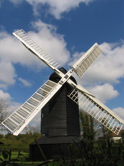
The main landmark is High Salvington windmill, which has been restored to a working condition over the last 30 years. The windmill is open every first and third Sunday afternoon during the months April to September, for the public to view.
Commercial
The neighbourhood has a shop, The Village Shop which includes a bakery, post office and general store.
Religious
Politics
Together with Findon Valley, High Salvington is part of the Cissbury electoral division of West Sussex.
Sport and recreation
Salvington, along with High Salvington shares its amateur football team, Salvington Football Club. Founded in 2009 by Phil Heckels, Darren Cooper and Nev Galvin, they compete in the Worthing & Horsham District Sunday League. The adult men's team won the 4th Division undefeated in their debut season. They play their home games at The Rotary, Hillbarn. Their badge pays recognition to the hillside settlement's landmark windmill.
Notable inhabitants
The actress Nancy Price lived in a cottage, 'Arcana', in Heather Lane.