
Peak Mount Rae Width 37 km (23 mi) E-W Elevation 3,218 m | Length 117 km (73 mi) N-S Area 2,172 km² | |
 | ||
Mountains Tornado Mountain, Beehive Mountain, Mount Lyall | ||
Hubert shooting high rock range naugatuck ct 04 09 16
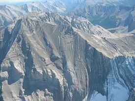
High Rock Range is a mountain range of the Canadian Rockies in southwestern Alberta and southeastern British Columbia, Canada.
Contents
It is a part of the Southern Continental Ranges and is located on the Continental Divide, north of the Crowsnest Pass and south of the Highwood Pass. It lies partly within Kananaskis Country.
Misty Range and Greenhills Range are subdivisions of the High Rock.
The High Rock Range covers a surface of 2,172 km² (838 mi²), has a length of 117 km (73 mi) (from north to south) and a width of 37 km (23 mi).
Peaks and mountainsEdit
- Mount Rae - 3,218 m (10,558 ft)
- Mist Mountain - 3,140 m (10,302 ft)
- Tornado Mountain - 3,099 m (10,167 ft)
- Courcelette Peak - 3,044 m (9,987 ft)
- Mount Lyall - 2,951 m (9,682 ft)
- Beehive Mountain - 2,895 m (9,498 ft)
- Mount Armstrong - 2,793 m (9,163 ft)
- Mount Muir - 2,758 m (9,049 ft)
- Allison Peak - 2,646 m (8,681 ft)
References
High Rock Range Wikipedia(Text) CC BY-SA