
 | ||
High Easter is a village and a civil parish in the Uttlesford District, in the English county of Essex. The population of the Civil Parish at the 2011 Census was 754. It is near the small city of Chelmsford and the hamlet of Stagden Cross. It is near the chief source of the River Can.
Contents
Map of High Easter, Chelmsford, UK
Description
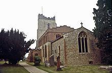
The village is situated approximately 75 metres above sea level and lies just west of the source of the River Can, which flows south eastwards from the village to meet the River Chelmer in Chelmsford. High Easter developed as a linear settlement to the west of the Parish Church and was known as “High Estra” before the Norman Conquest. “High” because of its elevated position, and also to distinguish the village from its neighbour – Good Easter – which is situated one and half miles to the south. “Estra” comes from the Anglo-Saxon word meaning “sheepfold”. The village was also latterly known as “High Easton”.
Before the conquest High Estra belonged to Ely Abbey, but at the time of the Conquest it was seized by Algor, the constable of the army. He was dispossessed by William the Conqueror who gave the Parish to Geoffrey de Magnaville. The principal Manor is called “High Easterbury”, which is situated to the south-west of the Parish Church. This important house was formerly held by the Earls of Essex and the Fitz-Piers, Bohun and Stafford families.
Amenities
High Easter has a post office and cafe, parish church, restaurant (The Punch Bowl), village hall, football pitch and cricket pitch.