
Airport type Public Elevation AMSL 3,877 ft / 1,182 m 9/27 9,000 Elevation 1,182 m | Website HelenaAirport.com Code HLN Phone +1 406-442-2821 | |
 | ||
Owner Helena Regional Airport Authority Address 2801-2873 Skyway Dr, Helena, MT 59602, USA | ||
Helena Regional Airport (IATA: HLN, ICAO: KHLN, FAA LID: HLN) is a public airport two miles northeast of Helena, in Lewis and Clark County, Montana. It is owned by the Helena Regional Airport Authority.
Contents
The National Plan of Integrated Airport Systems for 2011–2015 categorized it as a primary commercial service airport (more than 10,000 enplanements per year). Federal Aviation Administration records say the airport had 85,649 passenger boardings (enplanements) in calendar year 2008, 88,314 in 2009 and 98,193 in 2010.
Helena regional airport plans for the future
Facilities
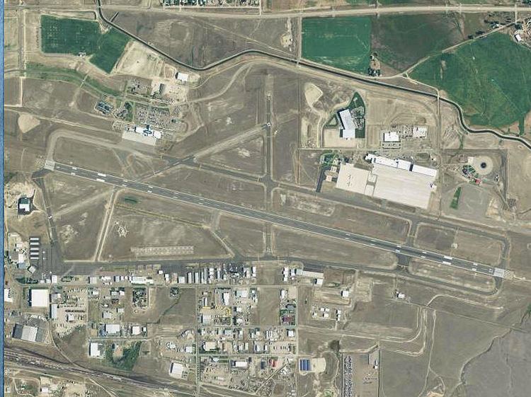
Helena Regional Airport covers 1,224 acres (495 ha) at an elevation of 3,877 feet (1,182 m). It has three asphalt runways: 9/27 is 9,000 by 150 feet (2,743 x 46 m); 5/23 is 4,644 by 75 feet (1,415 x 23 m); 16/34 is 2,989 by 75 feet (911 x 23 m).
In 2013 the airport had 38,877 aircraft operations, average 106 per day: 68% general aviation, 14% military, 14% air taxi, and 4% airline. 137 aircraft were then based at the airport: 74% single-engine, 14% multi-engine, 2% jet, 3% helicopter, 2% ultralight, and 5% military.
Airlines and destinations
Scheduled passenger service: