
District Spittal an der Drau Area code 04824 Elevation 1,288 m Local time Sunday 7:59 AM | Time zone CET (UTC+1) Vehicle registration SP Population 1,022 (2012) Postal code 9844 | |
 | ||
Weather 3°C, Wind NW at 23 km/h, 88% Humidity | ||
Heiligenblut am Großglockner (English: Holy Blood by the Großglockner) is a municipality in the district of Spittal an der Drau in Carinthia, Austria. The municipal area comprises the Katastralgemeinden of Apriach, Hof, Rojach, and Zlapp.
Contents
Map of Gemeinde Heiligenblut, 9844, Austria
Geography
At the northwestern edge of Carinthia and bordering East Tyrol and Salzburg state, Heiligenblut is in a high valley of the Hohe Tauern range of the European Alps at the foot of the Grossglockner, the highest mountain in Austria, and of the Pasterze Glacier. Other peaks include the Johannisberg and the Fuscherkarkopf in the north, both part of the Alpine divide and accordingly on the Carinthia-Salzburg border.
The municipality is also the southern starting point of the scenic Grossglockner High Alpine Road to Bruck in the state of Salzburg, the former Hochtor Pass, today the continuation of the B107 highway from Lienz in East Tyrol. Nearby attractions include the Heiligenblut-Roßbach-Schareck cable car up to 2,606 m (8,550 ft), an open-air museum, the Stockmühlen mills in Apriach with nine flume mills, Lake Kachelsee to the west, the Möll, Gößnitz and Leiter waterfalls, the Margaritzen reservoir, and Lake Sandersee.
The construction of the nearby railway tunnel to the Fleißalm mountain area at 1,798 m (5,899 ft) is unique in Europe. The 1.6 km-long (1-mile) tunnel is filled with water during the summer but serves as a railway tunnel leading to the Fleißalm winter sports region in winter.
History
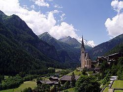
A chapel at Heiligenblut in the Duchy of Carinthia was first mentioned in 1271, containing a relic of the Blood of Christ. According to legend a flask of the Holy Blood, which is kept in a sacrament house, was brought here in 914 from the Hagia Sophia in Constantinople by the Danish knight Briccius. On his way home across the Alps, he was buried by an avalanche and hid the relic in an open wound at his calf. His corpse was later found by local peasants, where three ears of wheat broke through the snow (see the coat of arms). The Gothic pilgrimage church dedicated to Saint Vincent of Saragossa, with its prominent spire, was built between 1460-1491. The church also houses a late-Gothic winged altarpiece from 1520, and a crypt and tomb containing Briccius' mortal remains.
A transhumance agricultural as well as a gold mining from ancient history to the Middle Ages, Heiligenblut was a stop on the bridle path and later Roman road leading to the Hochtor Pass across the Alps, probably already in use during the Hallstatt culture which followed on from the Late Bronze Age. In 1834 Archduke John of Austria had a first mountain hut built beneath the pass, and a driveway was constructed from 1875. The opening of the Grossglockner Road in 1935 decisively promoted the economy of Heiligenblut as a tourism and mountaineering resort.
Politics
Seats in the municipal assembly (Gemeinderat) as of 2009 elections:
Twin towns
Literature
Kaufmann, J.: Örtliche Entwicklung und Ortsbild der Gemeinde Heiligenblut am Großglockner (master's thesis), Vienna, 1984.