
Population 261 (2011 census) Post town YORK Dialling code 01439 | Civil parish Harome Sovereign state United Kingdom Local time Friday 1:22 AM | |
 | ||
Weather 3°C, Wind SW at 14 km/h, 84% Humidity | ||
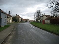
Harome is a small village and civil parish in the Ryedale district of North Yorkshire, England, around 2 miles south-east of the market town of Helmsley, and 24 miles north-east of York. The village has a population of 261 people according to the 2011 UK census, and a total land area of 9,539 sq metres. It is situated to the east of the River Riccal. The village has 109 households, with agriculture and retail trade being the two main employers for the residents. The name Harome simply means rocks/stones, and translates from old English meaning a heap of stones.
Contents
Map of Harome, York, UK
History
Until the nineteenth century, the village was known as Harum. By 1900 it had transitioned through Harom to its modern-day name of Harome.
In the 1870s, Harome was described as:
"HARUM, or HAROME, a chapelry in Helmsley parish, N. R. Yorkshire; on the rivers Rye and Riccal, 2 miles SE by E of Helmsley, and 4 N of Hovingham r. station. Post town, Helmsley, under York. Acres, 2, 303. Real property, £3, 093. Pop., 447. Houses, 90." – John Marius Wilson (1870–72)According to the UK census information, the population of Harome has decreased from 439 people in 1881 to 269 people between 1881 and 1961. More recently, the population has shown to be continually decreasing following the 2001 UK census falling to 252 people, however the 2011 census has shown an increase to 261 people- the first population increase since 1901.
Construction of the local church began in May 1861, on the site of a previously demolished building. St Saviour's Church, Harome was completed in August 1862, under the patronage of the Feversham Estate. The architect was Charles Barry Jr, whose father designed the Houses of Parliament. It was originally furnished by William Duncombe, who represented the North Riding of Yorkshire as a member of parliament between 1859 and 1867. The church contains glass from Hardman, and most recently a Millennium Cross produced by a local craftsman. Until 1863 Harome had been part of the parish of Helmsley.
Harome Methodist Church was built in 1909.
Industry
The 1881 UK census recorded that Harome's industry was predominately agriculturally based, with a total of 73 people working within agriculture, 71 of these were men. Domestic services was the second most popular occupation, with 15 people in total. There were also people within the parish who worked in other occupations such as dressmakers, textile fabrics and food and lodging, to name a few. The village also has a listed water mill dating back to the late eighteenth century.
In recent times the residents of Harome have shifted away from more agriculturally based occupations, which has been shown in the UK 2011 census. However, skilled trades is still the most popular occupation throughout the parish, with 36 people within this line of work. A lot of people are now predominately within a tertiary and quaternary based job, these include managers and directors, along with science researchers.
Housing and transport
Harome is a quaint village with several listed buildings along a wide main street.
Harome has most recently been categorised as being a 'village surrounded by sparsely populated countryside' by the Office for National Statistics. The housing within Harome is typically detached and terraced housing, with the average house price for a detached house at £269,371.
There are 183 vehicles within Harome, with 52.3% of the population accounting for 2 or more cars or vans. There are 4 bus routes serving Harome, all are school services. The nearest railway station to Harome is Malton railway station, which is located 10.84 miles away.
Geography
Harome is located at 54° 13′ 0″ N, 1° 0′ 0″ W (54.216667, −1). According to the Office for National Statistics, the Parish had a total land area of 9,539 sq metres, of which 9,113.61 is areas of green space and 86.93 sq metres is areas of water. The River Riccal runs to the west of Harome, which is met by many tributaries from the North York Moors, and runs through into the North Sea. Harome is situated 18.2 miles north-east from York, and 191 miles north from London.
Climate
Harome has a Maritime Temperate climate (Köppen climate classification Cfb) typical to the United Kingdom, characterised by cool summers and mild winters, due to a changeable and often overcast weather.