
Country United States County Hillsborough Time zone Eastern (UTC-5) Elevation 267 m Zip code 03449 | Incorporated 1779 Area code(s) 603 Area 80.8 km² Population 1,654 (2010) | |
 | ||
Weather -4°C, Wind W at 19 km/h, 51% Humidity | ||
Hancock is a town in Hillsborough County, New Hampshire, United States. The population was 1,654 at the 2010 census. Hancock is home to the Welch Family Farm Forest.
Contents
Map of Hancock, NH, USA
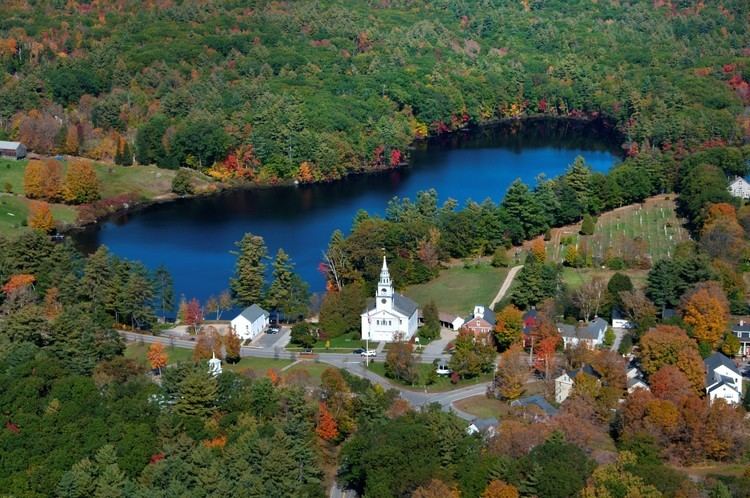
The main village of the town, where 204 people resided at the 2010 census, is defined as the Hancock census-designated place (CDP), and is located at the junction of New Hampshire routes 123 and 137.
History
Hancock started as an unidentified settlement on the Contoocook River, in lands known as Society Land or Cumberland, which had been reserved for the proprietors of the lands which became New Hampshire. First settled in 1764, the town was set off from Peterborough and incorporated in 1779, named Hancock in honor of John Hancock. A landowner of 1,875 acres (8 km2) in the community, Hancock was the first governor of the state of Massachusetts, president of the Continental Congress, and signer of the Declaration of Independence.
Almost every building on Main Street in downtown Hancock is listed on the National Register of Historic Places as part of the Hancock Village Historic District. Hancock's Meetinghouse is home to Paul Revere's #236 bell, which chimes on the hour, day and night. The town does not have paved sidewalks, but gravel paths leading from home to home.
Geography
According to the United States Census Bureau, the town has a total area of 31.2 square miles (81 km2), of which 30.0 sq mi (78 km2) are land and 1.2 sq mi (3.1 km2) are water, comprising 4.00% of the town. Hancock is drained by the Contoocook River. Powder Mill Pond is in the east, and Nubanusit Lake is on the western border. Skatutakee Mountain, the highest point in Hancock, has an elevation of 2,002 feet (610 m) above sea level. Hancock lies fully within the Merrimack River watershed.
Demographics
As of the census of 2000, there were 1,739 people, 706 households, and 494 families residing in the town. The population density was 58.0 people per square mile (22.4/km²). There were 814 housing units at an average density of 27.2 per square mile (10.5/km²). The racial makeup of the town was 98.39% White, 0.23% African American, 0.29% Native American, 0.40% Asian, 0.06% from other races, and 0.63% from two or more races. Hispanic or Latino of any race were 0.40% of the population.
There were 706 households out of which 31.2% had children under the age of 18 living with them, 62.6% were married couples living together, 5.1% had a female householder with no husband present, and 29.9% were non-families. 25.1% of all households were made up of individuals and 10.3% had someone living alone who was 65 years of age or older. The average household size was 2.46 and the average family size was 2.94.
In the town, the population was spread out with 25.0% under the age of 18, 3.9% from 18 to 24, 26.0% from 25 to 44, 28.3% from 45 to 64, and 16.8% who were 65 years of age or older. The median age was 43 years. For every 100 females there were 92.2 males. For every 100 females age 18 and over, there were 90.2 males.
The median income for a household in the town was $55,000, and the median income for a family was $64,423. Males had a median income of $40,000 versus $31,200 for females. The per capita income for the town was $29,445. About 2.7% of families and 3.8% of the population were below the poverty line, including 2.6% of those under age 18 and 4.1% of those age 65 or over.