
Length 103.6 km Year built 1900 Added to NRHP 15 June 2001 | Area 62 ha | |
 | ||
Componenthighways: Similar Waiʻanapanapa State Park, Haleakalā, Haleakalā National Park, Front Street, Iao Valley | ||
The road to hana 7 tips for first time travelers
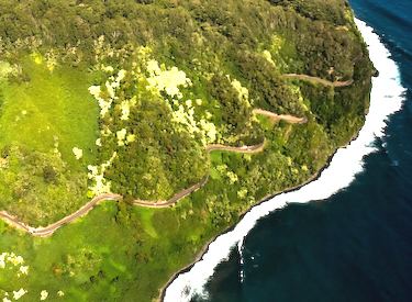
The Hāna Highway is a 64.4-mile (103.6 km) long stretch of Hawaii Routes 36 and 360 which connects Kahului with the town of Hāna in east Maui. On the east after Kalepa Bridge, the highway continues to Kīpahulu as Hawaii Route 31 (the Piilani Highway). Although Hāna is only about 52 miles (84 km) from Kahului, it takes about 2.5 hours to drive when no stops are made as the highway is very winding and narrow and passes over 59 bridges, 46 of which are only one lane wide. There are approximately 620 curves along Route 360 from just east of Kahului to Hāna, virtually all of it through lush, tropical rainforest. Many of the concrete and steel bridges date back to 1910 and all but one are still in use. That one bridge, badly damaged by erosion, has been replaced by a portable steel ACROW bridge erected by the United States Army Corps of Engineers.
Contents
- The road to hana 7 tips for first time travelers
- Map of Hana Hwy Hawaii USA
- Tourism
- History
- Major intersections
- References
Map of Hana Hwy, Hawaii, USA
In August 2000, the highway was designated as the Hāna Millennium Legacy Trail by President Bill Clinton, with the trail start designated in Pāʻia. The Hāna Highway was listed on the National Register of Historic Places on June 15, 2001.
Tourism
The Hāna Highway is a popular tourist attraction in Maui. Guidebooks often devote large sections to traveling the highway leading to the eastern side of Maui, documenting the many waterfalls and attractions that can be found along the way. Some of these attractions lie within or through private property and will often have "no trespassing" signs posted or even signs claiming that the attraction does not exist. All beaches in Hawaii are public. Some guidebooks document the "keep out" areas and ways past barbed wire fences and locked gates to reach attractions.
Beyond the town of Hāna, the Hāna Highway becomes Hawaii State Road 330 and leads to the ʻOheʻo Gulch where the Seven Sacred Pools are located within the Kipahulu Area of the Haleakala National Park.
Occasionally the dirt road past Route 31 is closed to traffic due to landslides. However, although it is somewhat rough in places, it is by no means a daunting or particularly dangerous road if taken slowly.
Scenic turnouts abound, including one for Wailua Falls near the Seven Sacred Pools in Oheʻo.
History
in the sixteenth century, Maui's King Pi'ilani conquered East Maui and drew Hana into his political sphere. Pi'ilani built the Alaloa, the "long road," from West Maui, a road on which travelers reportedly swung themselves over East Maui's rushing streams with ropes made of vines. Later, Piilani's son, Kihapiilani, extended the Alaloa into the Hana District. When completed, the road was 4' to 6' wide, 138 miles long, and paved with hand-fitted basalt (lava) rocks. Modern road construction to Hana began in the 1870s, with an unpaved road built to facilitate the construction of the Hämäkua Ditch. Part of The East Maui Irrigation System, the Hämäkua Ditch brought water from the rainforests of Haleakalā to semi-arid central Maui to support the sugarcane industry.
Road construction continued in the early 1900s and was extended piecemeal until the full road to Hana was officially opened on December 18, 1926. Construction of bridges continued through the 1930s and the road was not completely paved until the 1960s.
Major intersections
The entire route is in Maui County.