
Website www.hanpijesak.net Local time Wednesday 6:28 PM | Time zone CET (UTC+1) Area 320 km² Area code 57 | |
 | ||
Weather 4°C, Wind N at 16 km/h, 56% Humidity | ||
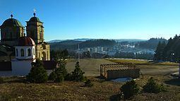
Planinski kamp jazavcije rupe han pijesak
Han Pijesak (Serbian Cyrillic: Хан Пијесак) is a town and municipality in the Republika Srpska entity of Bosnia and Herzegovina.
Contents
- Planinski kamp jazavcije rupe han pijesak
- Map of Han Pijesak Bosnia and Herzegovina
- Settlements
- 1971
- 1991
- References
Map of Han Pijesak, Bosnia and Herzegovina
Settlements
• Babine Gornje • Berkovina • Brložnik • Džimrije • Gođenje • Han Pijesak • Japaga • Jelovci • Kraljevo Polje • Kram • Krivače • Kusače • Malo Polje • Mrkalji • Nerići • Nevačka • Pjenovac • Plane • Podžeplje • Potkozlovača • Ravanjsko • Rečica • Rijeke • Rubinići • Stoborani • Žeravice • Kape
1971
In the 1971 Yugoslav census, there were 7,804 total citizens
1991
In 1991, the population of Han Pijesak municipality was 6,346, including:
References
Han Pijesak Wikipedia(Text) CC BY-SA