
Isolation 1.97 mi (3.17 km) Prominence 217 m Easiest route Hiking | Elevation 3,875 m | |
 | ||
Location Continental Divide inRocky Mountain National Park between Grand and Larimer counties, Colorado, U.S. Topo map USGS 7.5' topographic mapMcHenrys Peak, Colorado Similar Longs Peak, Taylor Peak, Otis Peak, Mount Ida, Mount Meeker | ||
Hallett Peak is a mountain summit in the northern Front Range of the Rocky Mountains of North America. The 12,720-foot (3,877 m) peak is located in the Rocky Mountain National Park Wilderness, 10.1 miles (16.2 km) southwest by west (bearing 240°) of the Town of Estes Park, Colorado, United States, on the Continental Divide between Grand and Larimer counties.
Contents
Map of Hallett Peak, Colorado 80510, USA
MountainEdit
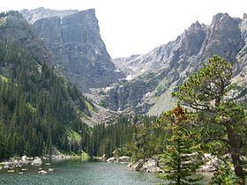
Hallett Peak is on the Continental Divide, flanked by Flattop Mountain to the north and Otis Peak to the south. Just to its east lie Emerald Lake, Dream Lake, and Nymph Lake, which are usually accessed from the Bear Lake Comfort Station.
The Northcutt-Carter Route of Hallett Peak is recognized in the historic climbing text Fifty Classic Climbs of North America. Non-technical climbers may reach the summit of Hallett Peak by hiking up the Flattop Mountain Trail to its highpoint, then walking south along the ridgeline and ascending the peak over talus piles.