
Area 643 km² Local time Wednesday 5:49 AM | Website www.halfeti.bel.tr District area 642.9 km² | |
 | ||
Weather 4°C, Wind W at 3 km/h, 89% Humidity | ||
Halfeti (Ottoman Turkish: روم قلعه, Rumkale, Kurdish: Xelfetî) is a small farming district on the east bank of the river Euphrates in Şanlıurfa Province in Turkey, 120 km from the city of Şanlıurfa. Population (2000 census) 33,467 (of which 2,608 were in the town of Halfeti, the majority being in the surrounding villages).
Contents
Map of Halfeti, 63950 Halfeti%2F%C5%9Eanl%C4%B1urfa Province, Turkey
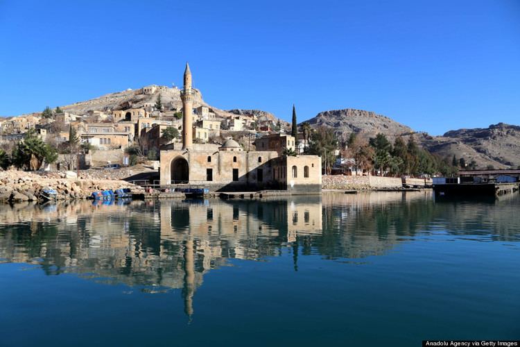
Most of the villages were submerged in the 1990s under the waters behind the dam on the Euphrates at Birecik. The town was therefore removed to the village of Karaotlak, the building of the new town is now complete.
History
The Assyrian King Shalmaneser III (855 BC) established a settlement here named Shitamrat. The town was subsequently settled by a number of civilisations and known as Urima (Ώριμα in Greek), Qal'a Rhomayta or Hesna d-Romaye (in Aramaic), to the Byzantine Greeks it was known as Romaion Koula (Ρωμαίων Κούλα - Roman castle), and the Arab conquerors mutated this name to Qal'at al-Rum.
The town was fortified and was besieged by the Mameluks in 1280, who conquered the outlying Christian villages but were unable to break into the fortress, which eventually fell to Sultan al-Ashraf in 1290. The Mameluks repaired the city walls and renamed the place Qal'at al-Muslimin although the names Urumgala and Rumkale persisted. The town was brought under Ottoman rule by Selim I.
Post-dam settlement
As part of the Southeastern Anatolia Project, aka GAP, several dams were constructed in the area and surrounding regions as part of a larger agricultural and economic initiative by the Turkish Government. The town of Halfeti was among those settlements, ancient and contemporary, that would remain under the rising water levels of the local dams and rivers following the execution of the GAP.
Until the area was flooded in 1999, the people lived from fishing in the Euphrates and farming on the riverbank, especially growing pistachios. Then the waters came and 'new' Halfeti was built. Some buildings, including the jail, were pulled down and rebuilt in the new town. The old town of Halfeti is only partially submerged and is beginning to attract visitors, especially those who hire a ferry to visit the ruins of the nearby fortress of Rumkale (Qal'at ar-Rum). The countryside is also attractive, although the green valley of the past is now underwater.
Opposite Halfeti stood the village of Kale Meydanı, which was also submerged, but the large landowners house was taken and reconstructed in the grounds of Harran University.