
OS grid reference SX432717 Post town GUNNISLAKE Dialling code 01822 | Sovereign state United Kingdom Postcode district PL18 Local time Sunday 12:22 AM | |
 | ||
Weather 10°C, Wind SW at 8 km/h, 97% Humidity | ||
Gunnislake (Cornish: Dowrgonna) is a large village in east Cornwall, England, United Kingdom. It is situated in the Tamar Valley approximately ten miles (16 km) north of Plymouth
Contents
Map of Gunnislake, UK
Gunnislake is in the civil parish of Calstock and is close to Cornwall's border with Devon which follows the course of the River Tamar. It has an electoral ward in its own name which includes much of Calstock and the surrounding area. The population at the 2011 census was 4,574
The village has a history of mining although this industry is no longer active in the area. During the mining boom in Victorian times more than 7000 people were employed in the mines of the Tamar Valley. During this period Gunnislake was held in equal standing amongst the richest mining areas in Europe.
History
Gunnislake's development was primarily due to the dramatic increase in mining and industrial activity in the nineteenth century. Mining provided around 7000 jobs at its peak in 1862. Most mining activity ceased in the late nineteenth century which has bequeathed interest for archaeologists and students of industrial heritage.
As well as mining, other industry such as brickworks and quarries were present. Nearby, locations such as Kit Hill, Morwellham Quay, Cotehele and Calstock were mined and quarried and the Tamar was used for transporting the raw material obtained from the works. Arsenic was produced at Greenhill, Gunnislake until at least 1930.
There has recently been discovered a significant Roman fort on the outskirts of Calstock, the largest known Roman site in Cornwall and the famous painting by Turner 'Crossing the Brook' exhibited in 1815 is in fact a view of Newbridge. Newbridge was built ca. 1520: it is 182 feet long and has seven arches. It is built of large regular granite blocks and is the best of the Cornish granite bridges.
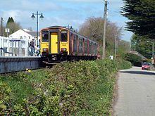
Contentiously debated in the local press, the future of Gunnislake's rail-link with Plymouth has, in recent years, come under threat by the proposed re-establishment of a disused railway line between Tavistock and Plymouth.
Geography
The area is mainly residential with a small handful of businesses ranging from pubs to garages and small shops. Gunnislake is located in the Tamar Valley designated Area of Outstanding Natural Beauty, though some recent industrial development has been attempted and achieved. Within early 2006 Hingston Down Quarry installed a new asphalt production tower which is easily noticeable as it is proud of the skyline of Gunnislake.
Since 2001, the village has annually hosted its own festival, encompassing a variety of events throughout a week-long celebration.
There is a King George's Field in memorial to King George V located in lower Gunnislake. It is also the home of Gunnislake Football Club.
Gunnislake railway station is the northern terminus of the Tamar Valley Line, which connects the villages of the Tamar valley with the city of Plymouth. (See also Plymouth, Devonport and South Western Junction Railway.) Gunnislake is now the terminus of the line but until 1966 it continued north to Callington. In 1994 the station was resited to remove a low road bridge.