
Created 1997 Area 122,825 km² | Abolished September 2015 Time zone WET (UTC+0) | |
 | ||
Points of interest Atlas Mountains, Agadir Id Aissa, Fort Bou Jerif | ||
Guelmim-Es Semara (Arabic: كلميم السمارة) was formerly one of the sixteen regions of Morocco from 1997 to 2015. It covered an area of 122,825 km² and had a population of 501,921 (2014 census). The regional capital was Guelmim.
Contents
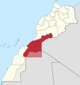
Map of Guelmim-Es Semara, Morocco
Geography
The southern half of Guelmin-Es Semara forms part of the Western Sahara. The region is bordered to the north by Souss-Massa-Drâa and to the west by Laayoune-Boujdour-Sakia El Hamra, with the Algerian province of Tindouf to the east. Its disputed territory in the Western Sahara borders the Mauritanian Tiris Zemmour Region. Guelmin-Es Semara has a coastline on the Atlantic Ocean, with the Spanish Canary Islands lying off it. The Draa River, at 1,100 km the longest in Morocco, flows into the Ocean near Tan-Tan.
The region was made up of the following provinces: