
Subregion Eastern Area 69 km² | Demonym(s) GuatapensesGuatapeños Local time Saturday 4:16 AM | |
 | ||
Time zone Colombia Standard Time (UTC-5) Weather 14°C, Wind NW at 2 km/h, 87% Humidity | ||
The rock of guatap unusual places
Guatapé is a town and municipality in Antioquia Department, Colombia. It is a part of the subregion of Eastern Antioquia. Guatapé is bordered on the north by Alejandría, San Rafael to the east, and Granada and El Peñol to the south. Guatapé is located in the outskirts of Medellín, bordering a reservoir created by the Colombian government for a hydro-electric dam, built in the late 1960s. This quaint town is the gathering place for "Las Vegas", or the small farms of the area. It is also a growing area of recreation for citizens of Medellín, and aims to be a tourist destination for foreign travellers.
Contents
- The rock of guatap unusual places
- Map of GuatapC3A9 Antioquia Colombia
- History
- Demographics
- Ethnography
- Sites of interest
- La Piedra
- References
Map of Guatap%C3%A9, Antioquia, Colombia
New resorts, several restaurants, and rental homes along the lake are available for visitors. Each building has tiles along the facade's lower walls in bright colors and dimensioned images. Many of the tiles are tied to the products sold by the shops, or the beliefs of the residents. Others are cultural images of the farming heritage of the community.
History
Before Iberian conquistadors reached the area in the 16th century, this territory was inhabited by indigenous ethnic groups, some controlled by a cacique named Guatape. In his honor, the town was named after him. The name "Guatapé", comes from the Quechua language, related to "stones and water". Another name that the town had had in the past is "La Ceja de Guatapé".
In 1714, the indigenous people under Guatapé of this region were grouped into a shelter known as "San Antonio de Remolinos Peñol". Traces of their existence come from clay urns found in the town of Alto Verde, and several archaeological sites not yet studied in the villages of La Peña, La Piedra, El Roble and El Rosario.
Guatapé was founded 4 October 1811, by the Spaniard Don Francisco Giraldo y Jimenez. It was declared a municipality in September 1867.
Guatapé has undergone changes throughout its history. It was predominately a farming town that relied on livestock, agriculture and mining. Empresas Públicas de Medellín built a large hydroelectric complex here in the 1970s. This megaproject produced large impacts on social, economic, political, environmental and cultural development in the locality. With the construction of this dam, Guatapé became one of the most important electric production centers in the country.
Demographics
Total Population: 5,623 inhabitants (2009)
Literacy: 92.3% (2005)
Ethnography
According to figures presented by DANE census in 2005, the ethnic makeup of the township is the following:
Sites of interest
La Piedra
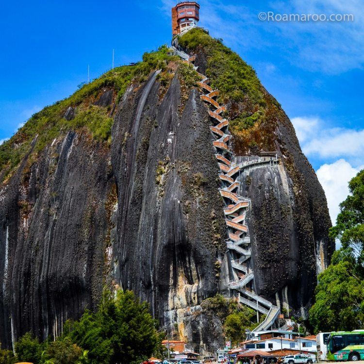
The "Peñol Rock" (La piedra del Peñol) that borders the lake is a rock formation, that formed along the Antioquia Rock Base (batolito de antioquia), 70 million years ago. With 2/3 of its height below ground, the exposed vertical face is over 200 meters high and visible from throughout the surrounding countryside. Visitors can scale the rock via a staircase built into one side, a path that includes more than 649 steps to the top. On the flat top of the rock, food vendors offer outdoor tables overlooking vistas that stretch to the horizon in every direction. Above the food vendors are two gift shops, and an open-air viewing area to see the spectacular scenery.
Also you can visit two monasteries, that belong to the "Benedictinos" Communities. The monks are devoted to receive and share with visitors.
There are many Ferries available, to take tours around the dam, and to visit islands known as "The Fantasy Island Hotel", located at 3 NM, north of Guatapé shore. There are also many extreme and traditional water sports available.
Currently there is a project of constructing an ultralight airport.