
Length 80 km | ||
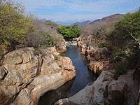 | ||
The Guatapurí River, or Rio Guatapurí in Spanish, is a river that flows from the eastern side of the Sierra Nevada de Santa Marta into the Cesar River in northern Colombia by the city of Valledupar. In the indigenous Chimila language, Guatapurí means "cold water".
Map of R%C3%ADo Guatapuri, Valledupar, Cesar, Colombia
Its main source is the Curiba Lake which is 4,400 metres (14,400 ft) above sea level. The Guatapurí is approximately 80 kilometres (50 mi) long. Among its major affluents are waters from the Curiba Lake, Donachui river, Capitanejo river, and Los Mangos river.
References
Guatapurí River Wikipedia(Text) CC BY-SA