
 | ||
The guarani aquifer
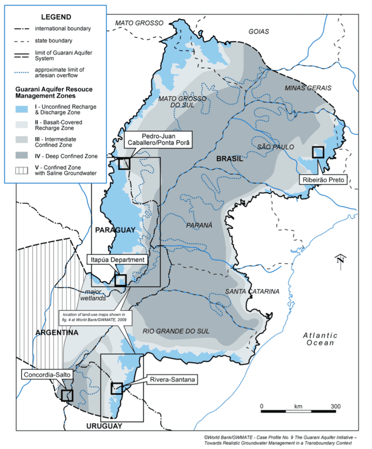
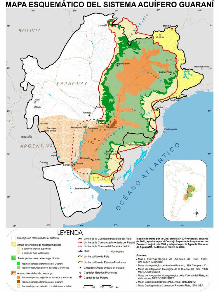
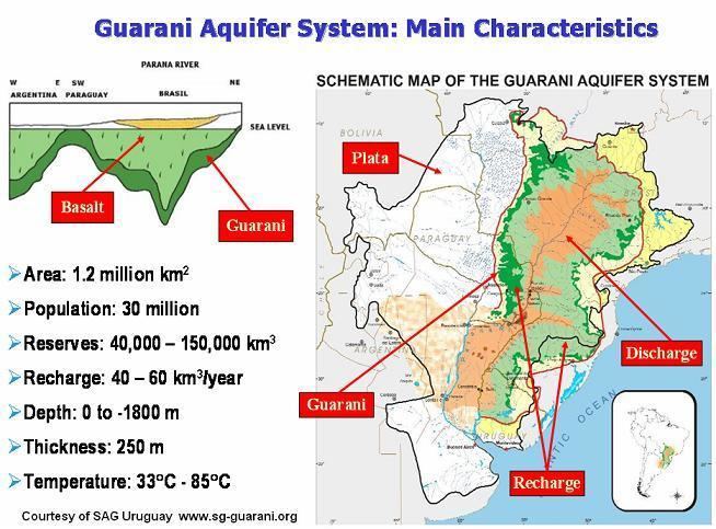
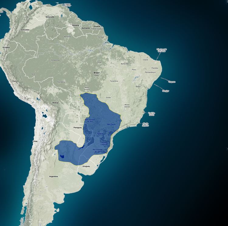
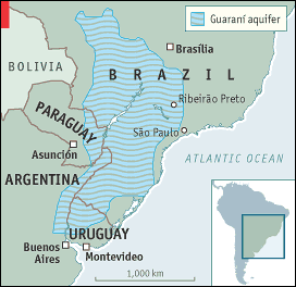
The Guarani Aquifer, located beneath the surface of Argentina, Brazil, Paraguay, and Uruguay, is one of the world's largest aquifer systems and is an important source of fresh water. Named after the Guarani people, it covers 1,200,000 square kilometres (460,000 sq mi), with a volume of about 40,000 cubic kilometres (9,600 cu mi), a thickness of between 50 metres (160 ft) and 800 metres (2,600 ft) and a maximum depth of about 1,800 metres (5,900 ft). It is estimated to contain about 37,000 cubic kilometres (8,900 cu mi) of water, with a total recharge rate of about 166 km³/year from precipitation. It is said that this vast underground reservoir could supply fresh drinking water to the world for 200 years. However, at closer inspection, if the world population were to stay at an equilibrium of about 6.96 billion, not even taking into account that babies need less water than grown adults, this figure reaches 1600 years, allowing about 9 liters per day per person. Due to an expected shortage of fresh water on a global scale, which environmentalists suggest will become critical in under 20 years, this important natural resource is rapidly becoming politicised, and the control of the resource becomes ever more controversial.
Contents
The great guarani aquifer
Geology of the aquifer
The Guarani Aquifer consists primarily of fluvial sandstones of the Piramboia Formation and aeolian sandstones of the Botucatu Formation, which were deposited during the Triassic and Jurassic periods. Over 90% of the total area is overlain by early Cretaceous basalts of the Serra Geral Formation. The basalt's low permeability allows it to act as an aquitard, providing a high degree of containment. This greatly reduces the rate of infiltration and subsequent recharge, but also isolates the aquifer from the vadose zone, subsequent surface-associated losses due to evaporation and evapotranspiration, and potential contamination.
The erosion exposes pieces of sandstone on aquifer’s banks, which are called outcrops.This is where the rain comes in and also where the contamination might happen. In general, the aquifer comprises a variety of quartz sand, well-rounded format, and has low clay content. Granulometric data indicate that over 50% of the grains have a diameter between 0.125 and 0.250 mm.
Research and monitoring of the aquifer in order to better manage it as a resource is considered important, as the population growth rate within its area is relatively high — resulting in higher consumption and pollution risks.
The countries over the aquifer are also the original four Mercosur countries.
Recharge of the Aquifer
The Recharge distribution is related to precipitation rate. Its complexity is due to the relation between them. This is not a direct relation. The infiltration rate depends on parameters that are variables in time and space.
Another important factor that contributes in Aquifer’s recharge is the importance of evapotranspiration. The soil, plants and atmosphere could be considered as components of a system physically related and dynamic. In some regions, the quantity of water that evaporates is bigger than runoff flow.
Research made by Brazilian Agricultural Research Corporation (Embrapa) in Ribeirão Preto - Brazil, from 1994 to 2001 has shown the agricultural activities use potential contaminants chemical products, offering risk of contamination for the groundwater.
Vegetal Interception is another factor that directly influences the quantity of water that infiltrates into the soil. According to Soares and Almeida (2001) they realized a study in the Eucalyptus area between October 1995 and September 1996. The interception during this period was evaluated in 11% of the precipitation value.