
Local time Saturday 3:54 AM | Area 10.64 km² Population 1,017 (2000) | |
 | ||
Weather 16°C, Wind E at 5 km/h, 100% Humidity | ||
Guaraguao (Barrio Guaraguao) is one of the 31 barrios in the municipality of Ponce, Puerto Rico. Along with Anón, Coto Laurel, Marueño, Quebrada Limón, Real, and San Patricio, and the coastal barrios of Canas and Capitanejo, Guaraguao is one of the municipality's nine bordering barrios. It borders the municipalities of Adjuntas and Peñuelas. The name of this barrio is of native Taino Indian origin. It was created in 1878.
Contents
- Map of Guaraguao Ponce Puerto Rico
- Location
- Boundaries
- Features and demographics
- Notable Landmarks
- References
Map of Guaraguao, Ponce, Puerto Rico
Location
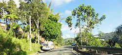
Guaraguao is a mountainous rural barrio located in the northwestern section of the municipality, northwest of the city of Ponce. Its location makes it susceptible to heavy rains, landslides, and road closings. The toponomy, or origin of the name, is related to the Guaraguao tree, Guarea trichilioides, in the Guarea ramiflora family, a tree that grows to heights between 20 and 70 feet with a maximum 3-foot wide trunk at the foot of mountains in the humid central zone of Puerto Rico.
Boundaries
Guaraguao is bounded on the North by PR-516 (roughly), on the South by the hills north of Tierras Buenas Road, and the hills south of Las Lomas Road, on the West by the hills west of A Street, PR-501 (roughly), and Las Lomas Road (roughly), and on the East by PR-503, Rabanos I Road, PR-10 (roughly), the hills west of PR-123.
In terms of barrio-to-barrio boundaries, Guaraguao is bounded in the North by Barrio San Patricio, and by Barrio Portugues of the municipality of Adjuntas, in the South by Magueyes and Marueño, in the West by Barrio Marueño, and by Barrio Rucio of the municipality of Peñuelas, and in the East by San Patricio and Tibes.
Features and demographics
Guaraguao has 12.85 square miles (33 km2) of land area and no water area. In 2000, the population of Guaraguao was 1,669 persons, and it had a density of 130 persons per square mile. Guaraguao is the seventh least densely populated barrio in the municipality of Ponce. Major roads serving Barrio Guaraguao are PR-10, PR-123, PR-501, PR-515, and PR-516. The communities of Las Lomas and Santas Pascuas are located in Guaraguao.
The highest point in Barrio Guaraguao stands at 3,280 feet and is located on the extreme northwestern tip of the barrio.
Notable Landmarks
Guaraguao is abundant in fauna and flora, and it is home to many creeks and brooks. The largest river in barrio Guaraguao is Río Canas, which empties into the Caribbean Sea after merging with Río Pastillo in the city of Ponce to become Rio Matilde. In a March 2010 competition sponsored by the Puerto Rico Water and Environment Association, the Guaraguao water filtering plant of the Puerto Rico Water Authority (Autoridad de Acueductos y Alcantarillados) was assessed to be the best-tasting water in Puerto Rico.