
Province Alberta | ||
 | ||
Grouard, also known as Grouard Mission, is a hamlet in northern Alberta within Big Lakes County. It was previously an incorporated municipality between 1909 and 1944,
Contents
Map of Grouard, AB, Canada
Grouard is located 13 kilometres (8.1 mi) north of Highway 2, approximately 171 kilometres (106 mi) northeast of Grande Prairie. It is the administrative office of the Kapawe'no First Nations.
History
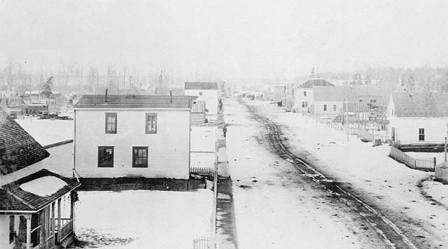
Grouard, named after Bishop Émile Grouard, was originally incorporated as a village on September 27, 1909 and then as a town in December, 1912. In 1913, the community had a population of more than 1,000, but was largely abandoned once the Edmonton, Dunvegan and British Columbia Railway (EDBCR) was built 12 miles (19 km) south of Grouard. Many of the residents and businesses moved to High Prairie, a community on the railway line.
Grouard reverted from town status to village status on June 7, 1940, and then dissolved from village status on January 15, 1944 to become part of Improvement District No. 764.
Difficult pastoral conditions in Grouard occasioned canonical permission for Catholic priests to be allowed to celebrate Mass four times per day on Sundays and certain holy days (contrary to the provisions of then-applicable 1917 CIC 806) being sought. This highly unusual permission was granted by Pope Paul VI for a five-year period beginning in 1967. See Canon Law Digest VI: 550.
Demographics
As a designated place in the 2016 Census of Population conducted by Statistics Canada, Grouard Mission recorded a population of 255 living in 85 of its 110 total private dwellings, a change of 2998842000000000000♠−15.8% from its 2011 population of 303. With a land area of 4.56 km2 (1.76 sq mi), it had a population density of 55.9/km2 (144.8/sq mi) in 2016.
As a designated place in the 2011 Census, Grouard Mission had a population of 303 living in 84 of its 106 total dwellings, a -5.9% change from its 2006 population of 322. With a land area of 4.38 km2 (1.69 sq mi), it had a population density of 69.18/km2 (179.2/sq mi) in 2011.
Education
Northern Lakes College has a campus in Grouard next to the Kapawe'no First Nations Reserve. The college offers family residences for students. The Native Cultural Arts Museum is a part of Northern Lakes College and is located in the Moosehorn Lodge at the Grouard campus. The Museum’s collection celebrates various aspects of Indigenous cultures, with a special focus on Métis peoples and the Woodland Cree of northern Alberta.
Northland School Division No. 61 hosts grades K-9. Students who continue from grade 9 travel by bus to attend high school in High Prairie. Grouard students also have the option to attend school from K-12 in High Prairie.