
Highest elevation 219 m (719 ft) Elevation 219 m Population 1,539 (2007) | Width 60 km (37 mi) Highest point Central Hill Area 2,326 km² Max length 50 km | |
 | ||
Points of interest Eningkirra Beach, Mundarringumanja Beach | ||
Groote eylandt spear fight
Groote Eylandt is the largest island in the Gulf of Carpentaria and the fourth largest island in Australia. It is the homeland of, and is owned by, the Warnindhilyagwa who speak the isolated Anindilyakwa language.
Contents
- Groote eylandt spear fight
- Map of Groote Eylandt Anindilyakwa NT 0822 Australia
- Groote eylandt a place to work a place to play promtotional video
- Administration
- Mining
- Fishing
- Environment
- History
- Media
- Notable people
- References
Map of Groote Eylandt, Anindilyakwa NT 0822, Australia
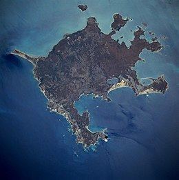
Groote Eylandt lies about 50 km (31 mi) from the Northern Territory mainland and eastern coast of Arnhem Land, about 630 km (391 mi) from Darwin, opposite Blue Mud Bay. The island measures about 50 km (31 mi) from east to west and 60 km (37 mi) from north to south; its area is 2,326.1 km2 (898.1 sq mi). It is generally quite low-lying, with an average height above sea level of 15 metres (49 ft), although Central Hill reaches an elevation of 219 metres (719 ft). It was named by the explorer Abel Tasman in 1644 and is Dutch for "Large Island" in an archaic spelling. The modern Dutch spelling is Groot Eiland.
Groote eylandt a place to work a place to play promtotional video
Administration
Together with Bickerton Island and a few smaller satellite islands, Groote Eylandt forms Anindilyakwa Ward of East Arnhem Region. It contains the communities of Angurugu, Alyangula, Umbakumba, Yadagba District, Uburamudja District and Sandy Hill (Groote Eylandt) and Milyakburra District (Bickerton Island).
Outside the local government subdivision is the mining company GEMCO town of Alyangula, which is unincorporated territory within the Northern Region of Northern Territory.
Mining
Groote Eylandt is part of the Arnhem Land Aboriginal Reserve. GEMCO, a South32 (60%) / Anglo American plc (40%) joint venture, operates a large manganese mine near the community of Angurugu. In operation since the early 1960s, the mine produces more than 3.8 million tonnes annually - about a quarter of the world's total.
Fishing
The island has until recently been open to the public only with permission, and the local Aboriginal Land Council did not encourage tourism. There is now a resort style hotel on the island and visitors are welcome. The island is becoming renowned for its fine Aboriginal rock art sites, arts and crafts and outstanding sport-fishing including sailfish, marlin, tuna, Spanish mackerel, giant trevally, queenfish, and coral trout.
Environment
The whole of Groote Eylandt and its surrounding waters lie within the Anindilyakwa Indigenous Protected Area. An unnamed islet off the north-eastern coast has been classified by BirdLife International as an important bird area because of its global importance as a roseate tern breeding site.
History
Prior to European settlement, Groote Eylandt had been inhabited by Aboriginal people for thousands of years and there had been regular contact between local Aboriginal people and Macassan traders, evident in the names of some Groote Eylandt settlements, such as Umbakumba, which can be traced back to a Macassan origin.
The first recorded sighting of Groote Eylandt was in 1623, by the Dutch ship Arnhem, under Willem van Coolsteerdt. However, the relative prevalence of the hereditary Machado-Joseph Disease in the Groote Eylandt community (a condition otherwise mainly to be found in the Azores) has been suggested as evidence of early contact with Portuguese sailors. However haplotype analysis of the gene and comparison of the gene in persons with Machado disease from Japan and Joseph disease from Portugal showed that the disease was actually derived from Japanese sailors and not Portuguese sailors. Japan used to trade with Macassan traders and presumably the genes were transferred to them and subsequently to the people on Groote Eylandt. The island was given its current name in 1644, when Tasman arrived.
The first European settlement on the island was established at Emerald River in 1921, in the form of a Christian mission by the Church Missionary Society. During World War II, in 1943, the mission moved to Angurugu, as the RAAF required the use of the mission's airstrip: the ruins of the RAAF base are still evident today. In 1856 the local aboriginal conglomerate that regularly passed was known as the Jurambunga tribe. The island was also used as a flying boat base by Qantas for a period of time. In 1979, control of the island was transferred to the local Aboriginal Town Council.
Groote Eylandt was converted to Aboriginal freehold title land following the passing of the Aboriginal Land Rights (NT) Act of 1976.
On May 20, 2008, the Federal Government signed a deal with local Aborigines from Groote Eylandt to lease land to the Government for 40 years. In return, the government will spend money in the community with the aim of improving housing, education and health in the area.
Media
The Eylandt Echo newsletter is produced each fortnight. The newsletter's goal is to keep the community up to date on local news, events and recreation. The Eylandt Echo is sponsored by GEMCO as a community service.
At the moment the people of Groote Eylandt are putting together a TV station showing a different variety of channels sponsored by GWN7.