
Time zone CET/CEST (UTC+1/+2) Population 6,997 (30 Jun 2009) Postal code 37247 Administrative region Kassel | Area 37.62 km² Local time Saturday 12:32 AM Dialling code 05604 | |
 | ||
Elevation 421 - 643 m (−1,689 ft) Weather 2°C, Wind S at 3 km/h, 84% Humidity | ||
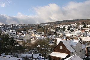
Großalmerode (or Grossalmerode) is a town in the Werra-Meißner-Kreis in Hesse, Germany.
Contents
- Map of GroC39Falmerode Germany
- Location
- Neighbouring communities
- Constituent communities
- History
- Town council
- Mayor
- Coat of arms
- Town partnerships
- Museums
- Buildings
- Sport
- Transport
- Famous people
- References
Map of Gro%C3%9Falmerode, Germany
Location
The small town, which has had town rights since 1775, lies 21 km east of Kassel in the Meißner-Kaufunger Wald Nature Park on the river Gelster. Here the constituent community of Laudenbach can also be found, in the Kaufunger Wald (range) between the Steinberg or Bilstein in the northwest and the Hirschberg in the southwest. Not far to the southeast stands the highest mountain in northeast Hesse, the Hoher Meißner.
Neighbouring communities
These are Witzenhausen, Hessisch Lichtenau, Helsa, Bad Sooden-Allendorf and Berkatal.
Constituent communities
Großalmerode’s Teilorte are Weißenbach, Trubenhausen, Uengsterode, Rommerode, Laudenbach and Epterode. Also within town limits are Bransrode, Gut Giesenhagen and Faulbach, although these are not outlying centres, but rather officially parts of the main town.
History
In 1386, today’s Großalmerode had its first documentary mention as Almerode. Town rights, though, only came in 1775.
Ceramics manufacture in mediaeval Großalmerode was very advanced. The products were exported worldwide for their high resistance to heat (1 100 to 1 200 °C).
At a gathering of the Christian Gemeinschaftsbewegung (“Fellowship Movement”) in 1907 there were ecstatic phenomena, the condemnation of which led to a rift between the Gemeinschaftsbewegung and the Pentecostal movement in 1909, through the so-called Berlin Declaration.
Town council
The municipal election held on 26 March 2006 yielded the following results:
Mayor
Since 2000, Andreas Nickel (SPD) has been the town’s mayor.
Coat of arms
The town’s arms might be described thus: Argent a mound vert, thereon three crucibles gules, one on top of the others, between two piles of Üller azure.
Üller which are made of Almerode clay, like the crucibles, are somewhat like marbles, but often much bigger.
Town partnerships
Museums
Buildings
Sport
With regard to sport, Großalmerode is well known for the 58 km-long mountain bike trail running across the Kaufunger Wald. Each year, with a few variations on the course, the so-called Bilstein Bike Marathon is held here, which draws mountain bikers from all over Germany and the Benelux countries to town. On the Schwarzenberg lies the TC Großalmerode tennis complex, with four courts.
Furthermore, the active members of the Turngemeinde 1863 Großalmerode e.V. (gymnastics club) and the FC Großalmerode 1920 Bezirksoberliga footballers have made names for themselves in past years. Between the main town and the outlying centre of Epterode lies the Männerspielplatz (“men’s playground”), where unusual sporting activities are on offer, such as digger driving, jeep driving and quad driving.
Transport
Through the main town runs Bundesstraße 451, which leads to Bundesstraße 7 near Helsa and Bundesstraße 27 near Witzenhausen.
The railway line from Walburg to the Großalmerode Ost end-of-line station was opened on 15 December 1915. Passenger service was ended on 2 June 1973. After conversion, the trains ran farther along the Gelstertalbahn to Witzenhausen Süd and Eichenberg.
There was one other railway line that branched off at Velmeden from this line; it led to the Großalmerode West end-of-line station.