
Topo map USGS Welcome Elevation 3,254 m | Easiest route Scramble, class 2 Prominence 218 m | |
 | ||
Similar Humboldt Peak, Hole in the Mountain Peak, Pilot Peak | ||
Hike to summit of greys peak 1st 14er 2013
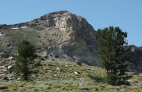
Greys Peak is the northernmost summit of the East Humboldt Range of Elko County in northeastern Nevada about 10 miles (16 km) southwest of the community of Wells. It rises over 5,000 feet (1,500 m) from the Humboldt Valley, making it one of the most visually prominent peaks in the area. To the west are Dennis Flats, Starr Valley, and remote Greys Lake, while to the east are Chimney Rock, Clover Valley, and popular Angel Lake. The summit is the start of a high crest running almost 10 miles (16 km) to the south.
Contents
- Hike to summit of greys peak 1st 14er 2013
- Map of Greys Peak Nevada 89823 USA
- Gopro top of greys peak
- Climbing
- References
Map of Greys Peak, Nevada 89823, USA
The peak is named after Enoch Grey, an early homesteader in nearby Starr Valley.
Gopro top of greys peak
Climbing
The most common approach starts at the Angel Lake Campground on the mountains western flank. A primitive trail, (class 2), climbs about 2,300 feet (700 m) from the parking lot.