
Length 28 km (17 mi) Area 270 km² | Terminus Glacial lake Termini Glacial lake | |
 | ||
Similar Grey Lake, Torres del Paine National, Lake Pehoé, Cordillera Paine, Nordenskjöld Lake | ||
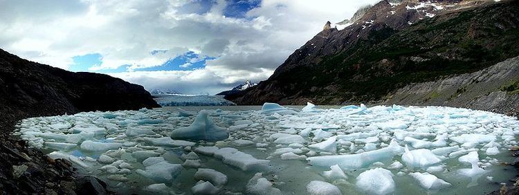
Grey Glacier is a glacier in the Southern Patagonian Ice Field, just west of the Cordillera del Paine. It flows southward into the lake of the same name. Before dividing in two front at its end, the glacier is 6 kilometers wide and over 30 meters high. In 1996 it occupied a total area of 270 km2 (100 sq mi) and a length of 28 km (17 mi).
Contents
- Map of Grey Glacier Torres de Paine Magallanes y la AntC3A1rtica Chilena Region Chile
- Surroundings
- References
Map of Grey Glacier, Torres de Paine, Magallanes y la Ant%C3%A1rtica Chilena Region, Chile
Surroundings
The Glacier is in the south end of the Southern Patagonia Ice Field. The surface of the lake can be seen when following the big circuit of Paine Mountain Range at John Garner Pass. There is another view of the glacier from the south shore of the lake where the glacier can be seen in the background, with fragments of ice floating close to the shore. It is located to the west side of the Torres del Paine National Park.