
Peak Cerro Paine Grande Age of rock 12 Myr Type of rock Granite | Elevation 2,884 m | |
 | ||
State/Province Magallanes y Antártica Chilena Similar Lake Pehoé, Torres del Paine National, Grey Lake, Grey Glacier, Nordenskjöld Lake | ||
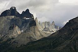
The Cordillera Paine is a small mountain group in Torres del Paine National Park in Chilean Patagonia. It is located 280 km (170 mi) north of Punta Arenas, and about 1,960 km south of the Chilean capital Santiago. It belongs to the Commune of Torres del Paine in Última Esperanza Province of Magallanes and Antártica Chilena Region. No accurate surveys have been published, and published elevations have been claimed to be seriously inflated, so most of the elevations given on this page are approximate. Paine means "blue" in the native Tehuelche (Aonikenk) language and is pronounced PIE-nay.
Contents
- Map of Cordillera del Paine Torres de Paine Magallanes y la AntC3A1rtica Chilena Region Chile
- Peaks
- Geology
- Hiking
- References
Map of Cordillera del Paine, Torres de Paine, Magallanes y la Ant%C3%A1rtica Chilena Region, Chile
Peaks
The highest summit of the range is Cerro Paine Grande, at 50°59′56″S 73°05′43″W. For a long time its elevation was claimed to be 3,050 m or 3,251 m, but in August 2011 it was ascended for the third time, measured using GPS and found to be 2,884 m.
The best-known and most spectacular summits are the three Towers of Paine (Spanish: Torres del Paine, 50°57′09″S 72°59′23″W).
The South Tower of Paine (about 2,500 m, at 50°57′33″S 72°59′42″W) is now thought to be the highest of the three, although this has not been definitely established. It was first climbed by Armando Aste.
The Central Tower of Paine (about 2,460 m or 8,100 feet) was first climbed in 1963 by Chris Bonington and Don Whillans, and the North Tower of Paine (about 2,260 m) was first climbed by Guido Monzino.
Other summits include the Cuerno Principal, about 2,100 m, and Cerro Paine Chico, which is usually correctly quoted at about 2,650 m.
Geology
The range is made up of a yellowish granite underlain by grey gabbro-diorite laccolith and the sedimentary rocks it intrudes, deeply eroded by glaciers. The steep, light colored faces are eroded from the tougher, vertically jointed granitic rocks, while the foothills and dark cap rocks are the sedimentary country rock, in this case flysch deposited in the Cretaceous and later folded.
The radiometric age for the quartz diorite at Cerro Paine is 12 ± 2 million years by the rubidium-strontium method and 13 ± 1 million years by the potassium-argon method. More precise ages of 12.59 ± 0.02 and 12.50 ± 0.02 million years for the earliest and latest identified phases of the intrusion, respectively, were achieved using U/Pb methods on single zircon crystals. Basal gabbro and diorite were dated by a similar technique to 12.472 ± 0.009 to 12.431 ± 0.006 million years. Thus, magma was intruded and crystallized over 162 ± 11 thousand years. High resolution dating and excellent 3-D exposure of the laccolith and its vertical feeding system allow detailed reconstruction of the Torres del Paine fossil magma chamber history.
Hiking
The Torres del Paine National Park—an area of 2,400 km²—was declared a Biosphere Reserve by the UNESCO in 1978 and is a popular hiking destination. There are clearly marked and well maintained paths and many refugios which provide shelter and basic services.
Hikers can opt for a day trip to see the towers, walk the popular "W" route in about five days, or trek the full circle in 8–9 days.
The "W" route is by far the most popular, and is named for the shape of the route. Hikers start and finish at either of the base points of the "W", performing each of the three shoots as a day trip. The five points of the W, from west to east, are:
The longer "circuit" walk includes all the sights of the "W", but avoids most backtracking, by connecting Glacier Grey and the Torres del Paine around the back of the mountain range.
Boats and buses provide transport between Hotel Las Torres, Refugio Paine Grande, and the park entrance at Laguna Amarga.
It is a national park and thus hikers are not allowed to stray from the paths. Camping is only allowed at specified campsites, and wood fires are prohibited in the whole park.