Neha Patil (Editor)

Grenadines Parish

Updated on
Edit
Like
Comment
Share on FacebookTweet on TwitterShare on LinkedInShare on Reddit
Capital City
  
Port Elizabeth

Area
  
44 km²

Elevation
  
304 m

Capital
  
Port Elizabeth

Grenadines Parish

Country
  
Saint Vincent and the Grenadines

Points of interest
  
Bequia, Canouan, Mayreau, Old Hegg Turtle Sanctuary, Macaroni Beach

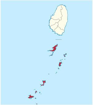
Grenadines is an administrative parish of Saint Vincent and the Grenadines. Its capital is Port Elizabeth.

Contents

Map of Grenadines, St Vincent and the Grenadines

  • Area: 44 km² (17 mi²)
  • Population: 9,200 (2000 estimates)
  • Islands

    The parish includes the northern Grenadine Islands:

  • All Awash Island (12°55′N 061°08′W)
  • Baliceaux (Baliceaux Island, 12°57′N 061°08′W)
  • Battowia (Battowia Island, 12°58′N 061°08′W)
  • Bequia (13°01′N 061°13′W)
  • Canouan (Canouan Island, 12°43′N 061°20′W)
  • Catholic Island (12°40′N 061°24′W)
  • Church Cay (12°57′N 061°08′W)
  • Dove Cay (12°41′N 061°21′W)
  • L'Islot (12°41′N 061°21′W)
  • Mayreau (12°39′N 061°23′W)
  • Mustique (12°53′N 061°11′W)
  • Petit Canouan (12°47′N 061°17′W)
  • Petit Cay (12°50′N 061°12′W)
  • Petit Mustique (12°51′N 061°12′W)
  • Petit Nevis (12°58′N 061°15′W)
  • Petit Saint Vincent (12°32′N 061°23′W)
  • Pigeon Island (12°57′N 061°17′W)
  • Prune Island (Palm Island, 12°35′N 061°24′W)
  • Quatre (Isle à Quatre, 12°57′N 061°15′W)
  • Rabbit Island (12°51′N 061°10′W)
  • Red Island (12°36′N 061°25′W)
  • Saint Elairs Cay (12°59′N 061°14′W)
  • Sand Cay (12°36′N 061°26′W)
  • Savan (Savan Island, 12°48′N 061°12′W)
  • The Pillories (Les Piloris, 12°54′N 061°10′W)
  • Tobago Cays (12°38′N 061°21′W)
  • Union Island (12°36′N 061°26′W)
  • Populated places

    The following populated places are located in the parish of Grenadine:

    References

    Grenadines Parish Wikipedia