
Country United States Opening date 1962 Height 74 m Opened 1962 Construction cost 46.5 million USD | Status Operational Length 519 m Construction began 1959 | |
 | ||
Dam volume 1,146 square miles (2,970 km) Similar Sugarloaf Mountain, Dam Site Recreation Area, Bull Shoals Dam, Cleburne County Historical, Wiiliam Carl Garner Vi | ||
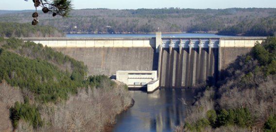
Greers Ferry Dam is located on the Little Red River in Cleburne County in the U.S. state of Arkansas. It impounds Greers Ferry Lake. The dam is located north of Little Rock.
Contents
Map of Greers Ferry Dam, Heber Springs, AR 72543, USA
Building the damEdit
Construction of the dam began in March 1959 and was completed in December 1962. The lake serves the Heber Springs area flood control, and is a site for recreation and power generation. When construction began on the dam in 1956, hundreds of workers showed up looking for work. The newly hired workers then rented empty houses next to the construction site, and workers were even building their own homes next to the soon-to-be lake. Once all the workers arrived, people and business owners saw an opportunity in this construction and built motels, shops, and stores next to the construction site so workers would have a place to shop and relax. Farmers also felt the benefit of the construction, as work on the lake created demand for livestock and agriculture.
DedicationEdit
After completion, the lake was dedicated on October 3, 1963 by John F. Kennedy. The trip was his last major public appearance before his fateful trip to Dallas on Nov. 22, 1963, where he was assassinated. This event marks the only time a sitting president has visited Cleburne County. In his remarks in Heber Springs, Kennedy explained that the Greers Ferry project and others like it were investments in Arkansas and the nation's future. He was right - after the lake filled, tourism boomed, many businesses opened and reopened, and Greers Ferry Lake became one of Arkansas' leading destinations. Today, many resort communities dot the shores of Greers Ferry Lake.