
Type of dam Concrete gravity Height 78 m Surface area 288.3 km² Construction began 1947 | Opening date 1951 Length 2,256 feet (688 m) Opened July 1951 | |
 | ||
Dam volume 2,100,000 cubic yards (1,600,000 m) Owner United States Army Corps of Engineers Similar Bull Shoals‑White River Stat, Powersite Dam, Greers Ferry Dam, Buffalo National River, Ozark Folk Center | ||
Fly fishing bull shoals dam white river arkansas
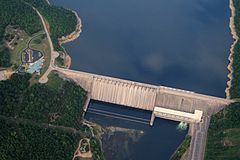
Bull Shoals Dam is a concrete gravity dam on the White River in northern Arkansas in the United States. The dam lies on the border of Marion and Baxter Counties, and forms Bull Shoals Lake, which extends well northwest into Missouri. Its main purposes are hydroelectricity production and flood control.
Contents
- Fly fishing bull shoals dam white river arkansas
- Map of Bull Shoals Dam Bull Shoals AR USA
- Bull shoals dam floodgates open mpg
- References
Map of Bull Shoals Dam, Bull Shoals, AR, USA
The dam was built by the U.S. Army Corps of Engineers in response to severe flooding between 1915 and 1927. President Franklin Delano Roosevelt authorized the construction of the dam as well as six others on the White River and its tributaries in the Flood Control Act of 1938. Construction started in June 1947 and the dam was completed in July 1951. When finished, the dam was one of the largest concrete structures in the world. From its completion until 2009, it is estimated that the dam has prevented about $225.5 million in flood damages.