
Area 203.5 km² Established 1956 | ||
 | ||
Governing body | ||
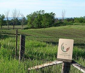
The Greenbelt (French: Ceinture de verdue) is a 203.5 square kilometres (78.6 sq mi) crescent of land within the present-day boundaries of the city of Ottawa, Ontario, Canada, in which real estate development is strictly controlled. It begins at Shirleys Bay in the west and extends to Green's Creek in the east. 149.5 square kilometres (57.7 sq mi) of the greenbelt is owned and managed by the National Capital Commission (NCC) and the rest is held by other federal government departments and private interests.
Contents
History
The greenbelt was proposed by Jacques Gréber in 1950 as part of his master plan for Ottawa, and the federal government started expropriating land in 1956. Its original purpose included the prevention of urban sprawl (which was threatening the rural areas surrounding the city), as well as to provide open space for the future development of farms, natural areas and government campuses. At the time, the greenbelt was "intended to circumscribe an area large enough for the accommodation of some 500,000 persons. The inner limit was chosen by considering what area could be economically provided with municipal services."
The present City of Ottawa comprises an extensive urban area surrounded by an even more extensive rural zone, a situation brought about by the January 1, 2001 amalgamation of Ottawa with several surrounding municipalities, both urban and rural. As a result, the Greenbelt no longer surrounds Ottawa, but rather it forms an arc through the inside of the city.
Today, land cover within the current Greenbelt comprises mainly forest, wetland, and fields - all with mixed use for recreation, conservation, farming, research, forestry. It also includes limited urban development, including government buildings and the Ottawa/Macdonald-Cartier International Airport. To date, the Ottawa Greenbelt is among the largest urban parks in the world.
The Greenbelt's success in curbing urban sprawl is difficult to measure because it is not known what the city would have looked like without it. As Ottawa had a population of 859,704 in 2005, it has clearly grown beyond what Gréber planned that the greenbelt should hold. Greenbelt detractors commonly reference the former city of Kanata, which lies just to the west of the greenbelt, as proof that development leapfrogged the greenbelt.
Proponents, however, point out that Kanata was planned as a separate and independent city contemporaneously with the greenbelt (in fact, it was to have a greenbelt of its own). Other areas of major development beyond the greenbelt (such as Stittsville in the west and Orléans in the east) are historical towns in their own right which grew outside the planning area of Ottawa.
Half a century later, it is hard to know whether the greenbelt delayed the popularity of these towns as bedroom communities. More recently, Barrhaven in the southwest and new developments in the southeast (along Riverside Drive and Bank Street) are developing quickly beyond the greenbelt. Regardless of its role in preventing urban sprawl, the presence of the Greenbelt has ensured that there are large protected rural and green areas in proximity to Ottawa's urban and suburban developed areas.
Development
The City of Ottawa is undergoing an Official Plan Review which, among other things, examines the need for additional land for urban purposes. It considers whether a discussion of urban land should include the option of some development within the Greenbelt and it is intended that this discussion will feed into the NCC’s review of the Greenbelt Master Plan. All views expressed in [the] White Paper are those of the City of Ottawa and not those of the National Capital Commission which owns and operates the Greenbelt. The City of Ottawa has identified more than 13,700 acres (55 km2) of the Greenbelt, worth about $1.6 billion, that could be developed, and in their view, without damaging its overall integrity. Then Environment Minister Jim Prentice, opposed development in what he considered an important part of the city's heritage. Prentice vowed to fight any such move.
Wildlife
The Greenbelt is home to a variety of wildlife:
Places of interest
Places of interest within the Greenbelt are from east to west: