
Prominence 80m OS grid SX563770 Listing Dewey | Elevation 538 m | |
 | ||
Topo map OS Landrangers 191, Explorer OL28 Similar High Willhays, Yes Tor, Beardown Tors, Great Links Tor, Hound Tor | ||
Great mis tor dartmoor east and west approaches
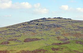
Great Mis Tor is a hill with a rocky outcrop situated in Dartmoor. It has been called one of the grandest hills in Devon, and lies above the River Walkham, about 4 miles north-east of Princetown.
Contents
Map of Great Mis Tor, Tavistock, UK
There is a notable rock basin on the peak, called the Mis Tor Pan or The Devil's Frying Pan.
The hill and surrounding area is on land owned by the Duchy of Cornwall, which is leased to the army. There have been cases of deaths and injury to the public caused by unexploded munitions in the area.
References
Great Mis Tor Wikipedia(Text) CC BY-SA