
Type artificial lake Surface area 1,500 acres (6.1 km) | Primary inflows Area 6.07 km² Inflow source Little Sandy River | |
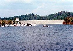 | ||
Grotto falls in grayson lake ky
Grayson Lake is a 1,500-acre (6.1 km2) reservoir in Carter and Elliott counties in Kentucky. It was created by the United States Army Corps of Engineers in 1968 by impounding the Little Sandy River with the Grayson Dam, an earthen structure 120 feet high, creating a maximum capacity of 118,990 acre-feet. Sections of Kentucky Route 7 were re-routed as a result of the lake's creation. KY 7 now traverses a modern highway stretch around the park, crossing the dam also.
Contents
- Grotto falls in grayson lake ky
- Map of Grayson Lake Kentucky USA
- Kayak grotto at grayson lake
- References
Map of Grayson Lake, Kentucky, USA
The lake is the major attraction of Grayson Lake State Park.
Kayak grotto at grayson lake
References
Grayson Lake Wikipedia(Text) CC BY-SA