
Mission type Gravitational research COSPAR ID 2009-013A Launch date 17 March 2009 Cost 350 million EUR (2009) Last contact 10 November 2013 | Operator ESA SATCAT no. 34602 Orbit height 268 km Decay date 11 November 2013 | |
 | ||
Mission duration Planned: 20 monthsFinal: 4 years, 7 months, 24 days Similar INTEGRAL, Venus Express, Soil Moisture and Ocea, Gaia, Herschel Space Observatory | ||
Goce satellite science performed before its destruction video
The Gravity Field and Steady-State Ocean Circulation Explorer (GOCE) was the first of ESA's Living Planet Programme satellites intended to map in unprecedented detail the Earth's gravity field. The spacecraft's primary instrumentation was a highly sensitive gravity gradiometer consisting of three pairs of accelerometers which measured gravitational gradients along three orthogonal axes.
Contents
- Goce satellite science performed before its destruction video
- Mission objectives
- Gravity map and model
- Findings
- Launch
- Operation
- End of mission and re entry
- Payload
- Power
- References
GOCE mapped the deep structure of the Earth's mantle and probed hazardous volcanic regions. It brought new insight into ocean behaviour; this in particular, was a major driver for the mission. By combining the gravity data with information about sea surface height gathered by other satellite altimeters, scientists were able to track the direction and speed of geostrophic ocean currents. The low orbit and high accuracy of the system greatly improved the known accuracy and spatial resolution of the geoid (the theoretical surface of equal gravitational potential on the Earth).
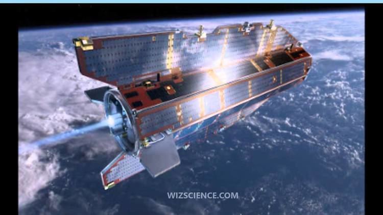
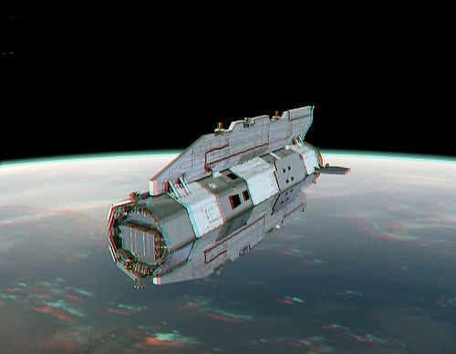
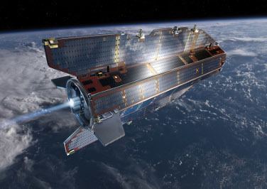
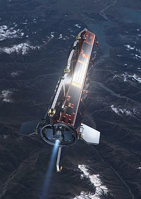
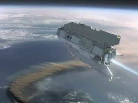
The satellite's unique arrow shape and fins helped keep GOCE stable as it flew through the upper thermosphere at an altitude of 255 kilometres (158 mi). Additionally, an ion propulsion system continuously compensated for the variable deceleration due to air drag without the vibration of a conventional chemically powered rocket engine, thus limiting the errors in gravity gradient measurements caused by non-gravitational forces and restoring the path of the craft as closely as possible to a purely inertial trajectory.
After running out of propellant, the satellite began dropping out of orbit and made an uncontrolled reentry on 11 November 2013.
Mission objectives
Gravity map and model
The final gravity map and model of the geoid will provide users worldwide with well-defined data product that will lead to:
Findings
The first Earth global gravity model based on GOCE data was presented at ESA’s Living Planet Symposium, in June 2010.
Initial results of the GOCE satellite mission were presented at the American Geophysical Union (AGU) 2010 Fall (Autumn) Meeting by Dr. Rory Bingham from Newcastle University, UK. The maps produced from the GOCE data show ocean currents in much finer detail than had been available previously. Even very small details like the Mann Eddy in the North Atlantic were visible in the data, as was the effect of Hurricane Igor (2010). Detailed analysis of GOCE's thruster and accelerometer data serendipitously revealed that it had detected the infrasound waves generated by the 2011 Tōhoku earthquake (whereupon it inadvertently became the first seismograph in orbit).
Later results from the GOCE data exposed details in the Earth's mantle including mantle plumes, ancient subduction zones, and remnants of the Tethys Ocean.
Launch
GOCE was launched from the Plesetsk Cosmodrome in northern Russia with a Rokot/Briz-KM vehicle on 17 March 2009 at 14:21 UTC. The Rokot is a modified UR-100N intercontinental ballistic missile that was decommissioned after the Strategic Arms Reduction Treaty. The launcher used the two lower liquid fuel stages of the original missile and was equipped with a Briz-KM third stage developed for precise orbit injection. GOCE was launched into a Sun-synchronous dusk-dawn orbit with an inclination of 96.70° and an ascending node at 18:00. Separation from the launcher was at 295 km. The satellite’s orbit then decayed over a period of 45 days to an operational altitude, planned at 270 km. During this time, the spacecraft was commissioned and the electrical propulsion system checked for reliability in attitude control.
The first launch attempt on 16 March 2009 was aborted due to a malfunction with the launch tower. Liftoff occurred successfully at 14:21 GMT on 17 March 2009. The Rokot launcher delivered the satellite northward over the Arctic. About 90 minutes later, after one orbital revolution and two Briz-KM upper-stage burns, the spacecraft was successfully released into a circumpolar orbit at 280 km altitude with 96.7° inclination to the Equator. Soon after the separation, contact was successfully established with the satellite.
Operation
In February 2010 a fault was discovered in the satellite's computer, which meant controllers were forced to switch control to the backup computer.
In July 2010, GOCE suffered a serious communications malfunction, when the satellite suddenly failed to downlink scientific data to its receiving stations. Extensive investigations by experts from ESA and industry revealed that the issue was almost certainly related to a communication link between the processor module and the telemetry modules of the main computer. The recovery was completed in September 2010: as part of the action plan, the temperature of the floor hosting the computers was raised by some 7 °C – resulting in restoration of normal communications.
In November 2010, the due completion date for the original 20-month mission before it was delayed by the glitches, it was decided to extend the mission lifetime till the end of 2012, in order to complete the original work and carry out a further 18-month mission to improve the collected data.
In November 2012 the orbit was lowered from 255 km to 235 km to get higher resolution data, at which time fuel remained for another 50 weeks.
End of mission and re-entry
In May 2013 a further lowering to 229 km took place.
The satellite ran out of propellant (xenon) in mid-October 2013, at which time it would take 2–3 weeks to re-enter.
On 18 October 2013, ESA reported that the pressure in the fuel system of GOCE's ion engine had dropped below 2.5 bar, which is the nominal operating pressure required to fire the engine. Subsequently end of mission was formally declared on 21 October when the ion drive stopped working at 03:16 UTC.
On 9 November 2013, a published report indicated that the satellite was expected to re-enter within a day or two. By this date, the perigee altitude had decayed to 155 km.
On 10 November ESA expected re-entry to occur between 18:30 UTC - 24:00 UTC, on 10 November; the most probable impact ground swath largely running over ocean and polar regions.
Its descending orbit on 11 November 2013 passed over Siberia, the western Pacific Ocean, the eastern Indian Ocean and Antarctica. The satellite finally disintegrated at around 1 a.m CET, according to the European Space Agency, near the Falkland Islands.
Payload
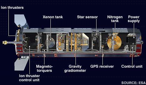
The satellite's main payload was the Electrostatic Gravity Gradiometer (EGG) to measure the gravity field of Earth. They were arranged in three pairs of ultra-sensitive accelerometers arranged in three dimensions that responded to tiny variations in the 'gravitational tug' of the Earth as it travelled along its orbital path. Because of their different position in the gravitational field they all experienced the gravitational acceleration of the Earth slightly differently. The three axes of the gradiometer allowed the simultaneous measurement of the five independent components of the gravity gradient tensor.
Other payload was an onboard GPS receiver used as a Satellite-to-Satellite Tracking Instrument (SSTI); a compensation system for all non-gravitational forces acting on the spacecraft. The satellite was also equipped with a laser retroreflector to enable tracking by ground-based lasers.
Power
GOCE had fixed solar panels, which produced 1,300 W of power and cover the Sun-facing side of GOCE.
The ion propulsion electric engine, designed and built at QinetiQ's space centre in Farnborough, England, ejected xenon ions at velocities exceeding 40,000 m/s, which compensated for the orbital decay losses. GOCE's mission ended when the 40 kg xenon fuel tank emptied (with a predicted lifetime of about 20 months).
An ESA report in June 2010 suggested that unusually low solar activity (meaning a calmer upper atmosphere, and hence less drag on the craft) meant the mission would be able to extend past its predicted 20 months due to fuel savings - possibly into 2014. In reality, the end of mission was formally declared on 21 October 2013 after 55 months, after being deployed for its final 11 months in a lower orbit (with greater air density and therefore greater fuel use).
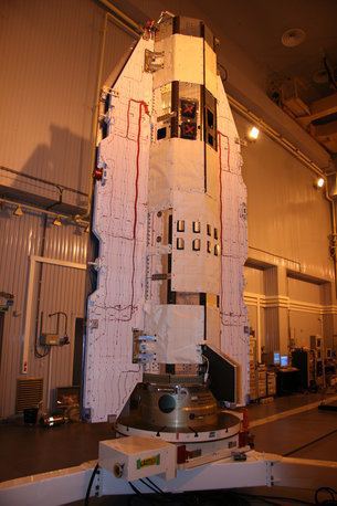
The 5 m × 1 m frame incorporates the fixed solar panels as fins to stabilise the spacecraft while it orbits through the residual air in the thermosphere.