Elevation 201 m (659 ft) Time zone CET (UTC+1) Local time Thursday 5:28 AM Postal code 22015 Dialling code 0344 | Demonym(s) Gravedonesi Area 40.8 km² | |
 | ||
Weather 5°C, Wind N at 6 km/h, 75% Humidity | ||
Gravedona ed uniti
Gravedona ed Uniti is a comune (municipality) in the Province of Como in the Italian region Lombardy, located about 80 kilometres (50 mi) north of Milan and about 40 kilometres (25 mi) northeast of Como.
Contents
- Gravedona ed uniti
- Map of 22015 Gravedona Province of Como Italy
- Gravedona ed uniti panorama canta tino
- References
Map of 22015 Gravedona Province of Como, Italy
The municipality of Gravedona ed Uniti contains the frazioni (subdivisions, mainly villages and hamlets) of Negrana, San Carlo, Segna, Trevisa, Traversa and, following an act of fusion passed by Lombardy Region, the annexed former municipalities of Consiglio di Rumo and Germasino, included on May 16, 2011.
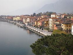
The town of Gravedona has a small harbour and overlooks Lake Como and the eastern shoreline. On 31 December 2004, it had a population of 2,669 and an area of 6.2 square kilometres (2.4 sq mi). After the enlargement of 2011, the municipality rose to an area of 40.8 square kilometres (15.8 sq mi) and a population of 4,222 inhabitants.
Gravedona ed Uniti borders the following municipalities: Colico, Domaso, Dongo, Dosso del Liro, Garzeno, San Nazzaro Val Cavargna, Peglio, Stazzona and, in Switzerland, Roveredo, Sant'Antonio and San Vittore.
