
Governing body National Park Service Nearest city Grand Marais | Established November 5, 1966 Management National Park Service | |
 | ||
Location Pictured Rocks National Lakeshore / Alger County, Michigan, United States | ||
Grand sable dunes 5 5 16
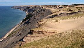
Grand Sable Dunes cover a 5-mile stretch along the southern shore of Lake Superior in the upper peninsula of Michigan in the eastern portion of the Pictured Rocks National Lakeshore.
Contents
- Grand sable dunes 5 5 16
- Map of Grand Sable Dunes Burt Township MI 49883 USA
- Grand sable dunes at pictured rocks national lakeshore
- References
Map of Grand Sable Dunes, Burt Township, MI 49883, USA
Glacial melt during the last major advance/retreat called the Marquette Readvance created the conditions for the formation of the Grand Sable Banks. Dominant northwesterly winds eventually caused blowing sand to become perched on the banks. Today, the Grand Sable Banks rise to heights of up to 300 ft. at a 35 degree angle from the shore of Lake Superior. The Grand Sable Dunes perched on top of these banks offers a desolate sandscape with jack pine forest near the edges.
In the late 19th century, loggers in the area built a wooden log slide from the top of the dunes at the Grand Sable Banks to Lake Superior below to facilitate the transportation of timber from the area. The location is a popular spot to view the Grand Banks and climb on the dunes. Visitors may also take a trail from the Grand Sable Visitors Center near the eastern end of the dunes or stop along a section of the dunes that borders on Grand Sable Lake.