
Population 180,000 Elevation 20 m (66 ft) Local time Friday 7:55 PM | Postcode(s) 2250 Time zone AEST (UTC+10) Postal code 2250 | |
 | ||
Weather 21°C, Wind S at 23 km/h, 79% Humidity Points of interest Australian Reptile Park, Bouddi National Park, Kibble Park, Monkey Mania Central C, Brisbane Water | ||
waterview 86 john whiteway drive gosford nsw 2250
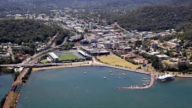
Gosford is a city located on the Central Coast of New South Wales, Australia, about 76 km north of the Sydney central business district. The city is situated at the northern extremity of Brisbane Water, an extensive northern branch of the Hawkesbury River estuary and Broken Bay.
Contents
- waterview 86 john whiteway drive gosford nsw 2250
- Map of Gosford NSW 2250 Australia
- Merindah apartments australia gosford nsw 2250
- History
- Demographics
- Newspapers
- Radio
- Climate
- City centre
- Facilities
- Notable people
- Notable residents
- Sister cities and twin towns
- References
Map of Gosford NSW 2250, Australia
The city is the administrative centre of the Central Coast region, which is the third largest urban area in New South Wales after Sydney and Newcastle. Gosford has been designated as an important growth centre under the NSW Metropolitan Strategy. The suburb's population was 3,392 in the 2011 census.
Merindah apartments australia gosford nsw 2250
History
Until white settlement, the area around Gosford was inhabited by the Guringai peoples, who were principally coastal-dwellers, and the Darginüng people that inhabited the hinterland. Along with the other land around the Hawkesbury River estuary, the Brisbane Water district was explored during the early stages of the settlement of New South Wales. In the early 19th century some pioneering European settlers began occupying the land, for timber-cutting (mainly ironbark and Australian red cedar), lime production and grazing.
Gosford itself was explored by Governor Phillip between 1788 and 1789. The area was difficult to access and settlement did not start before 1823. By the late 19th century the agriculture in the region was diversifying, with market gardens and citrus orchards occupying the rich soil left after the timber harvest. The road between Hawkesbury (near Pittwater) and Brisbane Water was a cart wheel track even in 1850.
Convicts once lived and worked in the Gosford area. In 1825, Gosford's population reached 100, of whom 50% were convicts.
East Gosford was the first centre of settlement. Gosford was named in 1839 after Archibald Acheson, 2nd Earl of Gosford – a friend of the then Governor of New South Wales George Gipps. Acheson's title derives its name from Gosford, a townland (sub-division) of Markethill in County Armagh in Northern Ireland.
In 1887, the rail link to Sydney was completed, requiring a bridge over the Hawkesbury River and a tunnel through the sandstone ridge west of Woy Woy. The introduction of this transport link and then the Pacific Highway in 1930 accelerated the development of the region.
Gosford became a town in 1885 and was declared a municipality in 1886.
Demographics
In the 2011 census, the most common countries of birth of people in Gosford were Australia 63.6%, England 4.4%, Mainland China 2.4%, India 1.9%, New Zealand 1.9% and South Korea 1.1%. The most common responses for religion were No Religion 24.3%, Catholic 21.6%, Anglican 18.0%, Buddhism 3.4% and Uniting Church 2.8%.
Newspapers
Gosford Community News has been published fortnightly by Ducks Crossing Publications since 2010.
Express Advocate: News Limited publish a free weekly suburban style newspaper in the News Local group.
Radio
Climate
Gosford has a humid subtropical climate (Köppen climate classification: Cfa) with warm summers and mild winters. In summer, temperatures average about 27-28 °C in the day with high humidity and about 17-18 °C at night. Winters are mild with cool overnight temperatures and mild to occasionally warm daytime temperatures with lower humidity. Average rainfall is 1333mm, much of which falls in the late summer and autumn. Records range from a maximum of 44.8 °C (113 °F) on 18 January 2013, to a low of −4.2 °C (24 °F) on 16 July 1970.
City centre
Gosford proper is located in a valley with President's Hill on the city's western border, Rumbalara Reserve on its eastern border, and Brisbane water to the city's south. Mann Street, Gosford's main street and part of the Pacific Highway, runs north-south and contains the frontage for much of the commercial district. The Central Coast Highway runs past Gosford's waterfront area, while its predecessor the Pacific Highway takes on several names through the CBD itself. Mann Street contains the main public transport links for Gosford, including Gosford railway station and the termini for several bus routes.
In the centre of Gosford is a shopping and community precinct, including Kibble Park, William Street Mall, Gosford City Library, the Imperial Shopping Centre, the Gosford Town Shopping Centre and a full range of shops, cafes, banks and services, especially along William Street Mall.
The Gosford CBD suffered a decline in the 1990s as commercial activity relocated to nearby Erina, particularly Erina Fair. To address this, the city has more recently redeveloped its park in the city centre, including a stream, a restaurant and outdoor performance facilities. This will be the beginning of the redevelopment of the CBD. A small number of high rise developments have also been built in the area to encourage a concentration of residents in a bid to stimulate the economy of local business. More high rise developments are planned.
A renewed period of optimism has followed several infrastructure investment projects including the full fibre optic telecommunications rollout of the National Broadband Network in 2012 in the city's CBD as well as the so-called Kibbleplex project, announced in 2013 that plans to house the new regional library, tertiary teaching rooms and associated organisations.
Facilities
Gosford is home to: